Hol geodata
Hol (Buskerud) is a seat of a second-order administrative division; located in Norway in Europe/Oslo (GMT+2) time zone. In our database, there are 488 cities with bigger population. Compared to other cities in Norway, 50.3% of cities are located further ↑North; 65% of cities are located further →East and 97.5% of cities have lower elevation than Hol. Note1


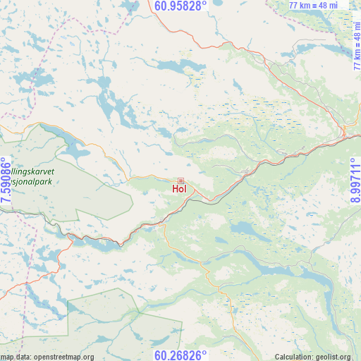
Hol GPS coordinates[2]
60° 36' 54.396" North, 8° 17' 38.328" East
| Map corner | latitude | longitude |
|---|---|---|
| Upper-left | 60.95828°, | 7.59086° |
| Center: | 60.61511°, | 8.29398° |
| Lower-right: | 60.26826°, | 8.99711° |
| Map W x H: | 76.7×76.7 km | = 47.7×47.7mi |
| max Lat: | 71.04137° ⇑50.3% North |
| Hol: | 60.61511° |
| min Lat: | ⇓49.7% South 58.0274° |
| min Long | Hol | max Long |
| 4.71485° | 8.29398° | 31.11066° |
| W 35%⇐ | ⇒65% E |
Elevation
Elevation of Hol is 540 m = 1772 ft, and this is 435.8 m = 1430 ft above average elevation for this country.
| Max E: |
897 m = 2943 ft | 2.5% |
| Hol | 540 m 1772 ft | |
| Avg. | 104.2 m = 342 ft | |
Min E: |
1 m = 3 ft | 97.5% |
See also: Norway elevation on elevation.city.
Geographical zone
Hol is located in North temperate zone (between Tropic of Cancer and the Arctic Circle). Distance of this North polar circle is 661.4 km =411 mi to North.| Distance of | km | miles | from Hol |
|---|---|---|---|
| North Pole | 3267.3 | 2030.2 | to North |
| Arctic Circle | 661.4 | 411 | to North |
| Tropic Cancer | 4133.8 | 2568.6 | to South |
| Equator | 6739.8 | 4187.9 | to South |


Nearby cities:
15 places around Hol: (largest is in red/bold)
• Aurdal
69.9 km =43.4 mi,  60°
60°
• Aurlandsvangen
68.3 km =42.4 mi,  298°
298°
• Eidfjord
68.8 km =42.8 mi,  256°
256°
• Fagernes
65.5 km =40.7 mi,  50°
50°
• Flå
67.1 km =41.7 mi,  107°
107°
• Geilo
10.3 km =6.4 mi,  208°
208°
• Gol
36.8 km =22.9 mi,  74°
74°
• Hemsedal
31 km =19.3 mi,  27°
27°
• Leira
67.1 km =41.7 mi, 53°
• Nesbyen
44.5 km =27.7 mi,  96°
96°
• Rødberg
52.7 km =32.7 mi,  137°
137°
• Slidre
64.4 km =40 mi,  35°
35°
• Trøim
31.1 km =19.3 mi, 28°
• Vang
58.7 km =36.5 mi,  14°
14°
• Ål
14.6 km =9.1 mi,  83°
83°
Sources, notices
• [Note1] Compared only with cities in Norway existing in our database
• [Src1] Map data: © OpenStreetMap contributors (CC-BY-SA)
• [Src2] Other city data from geonames.org with taken over terms of usage.
• [Src3] Geographical zone / Annual Mean Temperature by Robert A. Rohde @ Wikipedia
