Flå geodata
Flå (Buskerud) is a seat of a second-order administrative division; located in Norway in Europe/Oslo (GMT+2) time zone. In our database, there are 488 cities with bigger population. Compared to other cities in Norway, 53.8% of cities are located further ↑North; 56.5% of cities are located further →East and 73.9% of cities have lower elevation than Flå. Note1


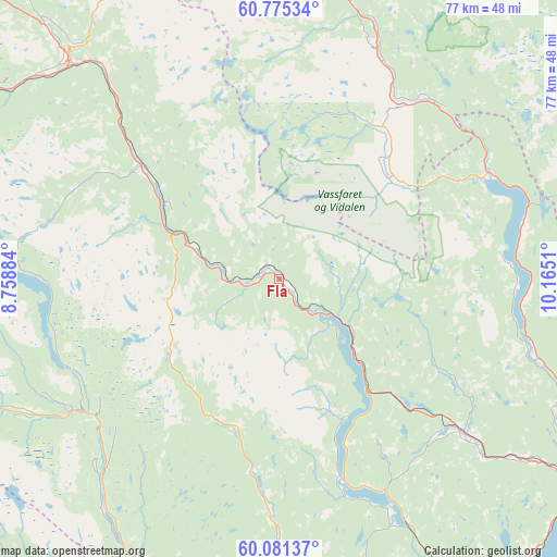
Flå GPS coordinates[2]
60° 25' 48.756" North, 9° 27' 43.092" East
| Map corner | latitude | longitude |
|---|---|---|
| Upper-left | 60.77534°, | 8.75884° |
| Center: | 60.43021°, | 9.46197° |
| Lower-right: | 60.08137°, | 10.1651° |
| Map W x H: | 77.2×77.2 km | = 48×48mi |
| max Lat: | 71.04137° ⇑53.8% North |
| Flå: | 60.43021° |
| min Lat: | ⇓46.2% South 58.0274° |
| min Long | Flå | max Long |
| 4.71485° | 9.46197° | 31.11066° |
| W 43.5%⇐ | ⇒56.5% E |
Elevation
Elevation of Flå is 140 m = 459 ft, and this is 35.8 m = 117 ft above average elevation for this country.
| Max E: |
897 m = 2943 ft | 26.1% |
| Flå | 140 m 459 ft | |
| Avg. | 104.2 m = 342 ft | |
Min E: |
1 m = 3 ft | 73.9% |
See also: Norway elevation on elevation.city.
Geographical zone
Flå is located in North temperate zone (between Tropic of Cancer and the Arctic Circle). Distance of this North polar circle is 682 km =423.8 mi to North.| Distance of | km | miles | from Flå |
|---|---|---|---|
| North Pole | 3287.9 | 2043 | to North |
| Arctic Circle | 682 | 423.8 | to North |
| Tropic Cancer | 4113.3 | 2555.9 | to South |
| Equator | 6719.2 | 4175.1 | to South |


Nearby cities:
15 places around Flå: (largest is in red/bold)
• Aurdal
55 km =34.2 mi,  357°
357°
• Bagn
43.9 km =27.3 mi,  6°
6°
• Bruflat
51.8 km =32.2 mi, 10°
• Gol
41.3 km =25.7 mi,  316°
316°
• Hallingby
43.5 km =27 mi,  113°
113°
• Hønefoss
52.6 km =32.7 mi,  123°
123°
• Jevnaker
55.1 km =34.2 mi, 112°
• Nesbyen
24.9 km =15.5 mi,  307°
307°
• Noresund
29.2 km =18.1 mi,  162°
162°
• Prestfoss
44.1 km =27.4 mi,  167°
167°
• Rollag
50.4 km =31.3 mi,  190°
190°
• Rødberg
33.6 km =20.9 mi,  237°
237°
• Sokna
33.3 km =20.7 mi,  129°
129°
• Tyristrand
51.9 km =32.2 mi,  137°
137°
• Ål
54.1 km =33.6 mi,  294°
294°
Sources, notices
• [Note1] Compared only with cities in Norway existing in our database
• [Src1] Map data: © OpenStreetMap contributors (CC-BY-SA)
• [Src2] Other city data from geonames.org with taken over terms of usage.
• [Src3] Geographical zone / Annual Mean Temperature by Robert A. Rohde @ Wikipedia
