Slidre geodata
Slidre (Oppland) is a seat of a second-order administrative division; located in Norway in Europe/Oslo (GMT+2) time zone. In our database, there are 488 cities with bigger population. Compared to other cities in Norway, 56.2% of cities are located further ↓South; 60% of cities are located further →East and 94.6% of cities have lower elevation than Slidre. Note1


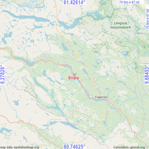
Slidre GPS coordinates[2]
61° 5' 16.872" North, 8° 58' 53.076" East
| Map corner | latitude | longitude |
|---|---|---|
| Upper-left | 61.42614°, | 8.27828° |
| Center: | 61.08802°, | 8.98141° |
| Lower-right: | 60.74625°, | 9.68453° |
| Map W x H: | 75.6×75.6 km | = 47×47mi |
| max Lat: | 71.04137° ⇑43.8% North |
| Slidre: | 61.08802° |
| min Lat: | ⇓56.2% South 58.0274° |
| min Long | Slidre | max Long |
| 4.71485° | 8.98141° | 31.11066° |
| W 40%⇐ | ⇒60% E |
Elevation
Elevation of Slidre is 420 m = 1378 ft, and this is 315.8 m = 1036 ft above average elevation for this country.
| Max E: |
897 m = 2943 ft | 5.4% |
| Slidre | 420 m 1378 ft | |
| Avg. | 104.2 m = 342 ft | |
Min E: |
1 m = 3 ft | 94.6% |
See also: Norway elevation on elevation.city.
Geographical zone
Slidre is located in North temperate zone (between Tropic of Cancer and the Arctic Circle). Distance of this North polar circle is 608.8 km =378.3 mi to North.| Distance of | km | miles | from Slidre |
|---|---|---|---|
| North Pole | 3214.7 | 1997.5 | to North |
| Arctic Circle | 608.8 | 378.3 | to North |
| Tropic Cancer | 4186.4 | 2601.3 | to South |
| Equator | 6792.4 | 4220.6 | to South |


Nearby cities:
15 places around Slidre: (largest is in red/bold)
• Aurdal
29.6 km =18.4 mi,  127°
127°
• Bagn
42.7 km =26.5 mi, 133°
• Bruflat
42 km =26.1 mi,  122°
122°
• Dokka
65.3 km =40.6 mi, 115°
• Fagernes
17.7 km =11 mi, 130°
• Forset
63.7 km =39.6 mi,  78°
78°
• Gol
43 km =26.7 mi,  182°
182°
• Heggenes
7.8 km =4.8 mi,  37°
37°
• Hemsedal
34.1 km =21.2 mi,  222°
222°
• Hol
64.4 km =40 mi, 215°
• Leira
21.4 km =13.3 mi, 127°
• Nesbyen
58.2 km =36.2 mi,  173°
173°
• Trøim
33.8 km =21 mi, 221°
• Vang
22.3 km =13.9 mi,  280°
280°
• Ål
55.8 km =34.7 mi,  204°
204°
Sources, notices
• [Note1] Compared only with cities in Norway existing in our database
• [Src1] Map data: © OpenStreetMap contributors (CC-BY-SA)
• [Src2] Other city data from geonames.org with taken over terms of usage.
• [Src3] Geographical zone / Annual Mean Temperature by Robert A. Rohde @ Wikipedia
