Leira geodata
Leira (Oppland) is a populated place; located in Norway in Europe/Oslo (GMT+2) time zone. With population of 771 people, there are 363 cities with bigger population in this country. Compared to other cities in Norway, 55.2% of cities are located further ↓South; 57.3% of cities are located further →East and 94.6% of cities have lower elevation than Leira. Note1


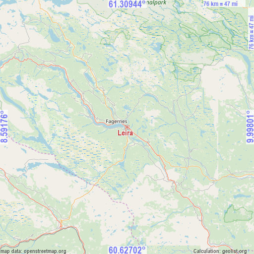
Leira GPS coordinates[2]
60° 58' 12.216" North, 9° 17' 41.568" East
| Map corner | latitude | longitude |
|---|---|---|
| Upper-left | 61.30944°, | 8.59176° |
| Center: | 60.97006°, | 9.29488° |
| Lower-right: | 60.62702°, | 9.99801° |
| Map W x H: | 75.9×75.9 km | = 47.2×47.2mi |
| max Lat: | 71.04137° ⇑44.8% North |
| Leira: | 60.97006° |
| min Lat: | ⇓55.2% South 58.0274° |
| min Long | Leira | max Long |
| 4.71485° | 9.29488° | 31.11066° |
| W 42.7%⇐ | ⇒57.3% E |
Elevation
Elevation of Leira is 420 m = 1378 ft, and this is 315.8 m = 1036 ft above average elevation for this country.
| Max E: |
897 m = 2943 ft | 5.4% |
| Leira | 420 m 1378 ft | |
| Avg. | 104.2 m = 342 ft | |
Min E: |
1 m = 3 ft | 94.6% |
See also: Norway elevation on elevation.city.
Geographical zone
Leira is located in North temperate zone (between Tropic of Cancer and the Arctic Circle). Distance of this North polar circle is 621.9 km =386.4 mi to North.| Distance of | km | miles | from Leira |
|---|---|---|---|
| North Pole | 3227.8 | 2005.7 | to North |
| Arctic Circle | 621.9 | 386.4 | to North |
| Tropic Cancer | 4173.3 | 2593.2 | to South |
| Equator | 6779.2 | 4212.4 | to South |


Nearby cities:
15 places around Leira: (largest is in red/bold)
• Aurdal
8.2 km =5.1 mi,  128°
128°
• Bagn
21.5 km =13.4 mi,  139°
139°
• Bruflat
20.8 km =12.9 mi,  116°
116°
• Dokka
44.7 km =27.8 mi,  109°
109°
• Fagernes
3.8 km =2.4 mi,  297°
297°
• Forset
52.4 km =32.6 mi,  60°
60°
• Gol
35.4 km =22 mi,  212°
212°
• Heggenes
22.8 km =14.2 mi,  327°
327°
• Hemsedal
41.8 km =26 mi,  253°
253°
• Nesbyen
45.9 km =28.5 mi,  193°
193°
• Segalstad bru
57.5 km =35.7 mi, 60°
• Slidre
21.4 km =13.3 mi,  307°
307°
• Trøim
41.2 km =25.6 mi, 252°
• Vang
42.5 km =26.4 mi,  293°
293°
• Ål
54.9 km =34.1 mi,  226°
226°
Sources, notices
• [Note1] Compared only with cities in Norway existing in our database
• [Src1] Map data: © OpenStreetMap contributors (CC-BY-SA)
• [Src2] Other city data from geonames.org with taken over terms of usage.
• [Src3] Geographical zone / Annual Mean Temperature by Robert A. Rohde @ Wikipedia
