Fauske geodata
Fauske (Nordland) is a seat of a second-order administrative division; located in Norway in Europe/Oslo (GMT+2) time zone. With population of 5,953 people, there are 75 cities with bigger population in this country. Compared to other cities in Norway, 87.2% of cities are located further ↓South; 90.2% of cities are located further ←West and 52.7% of cities have higher elevation than Fauske. Note1


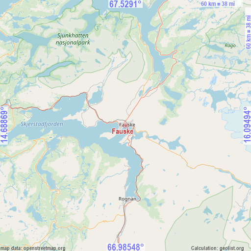
Fauske GPS coordinates[2]
67° 15' 31.788" North, 15° 23' 30.516" East
| Map corner | latitude | longitude |
|---|---|---|
| Upper-left | 67.5291°, | 14.68869° |
| Center: | 67.25883°, | 15.39181° |
| Lower-right: | 66.98548°, | 16.09494° |
| Map W x H: | 60.4×60.4 km | = 37.5×37.5mi |
| max Lat: | 71.04137° ⇑12.8% North |
| Fauske: | 67.25883° |
| min Lat: | ⇓87.2% South 58.0274° |
| min Long | Fauske | max Long |
| 4.71485° | 15.39181° | 31.11066° |
| W 90.2%⇐ | ⇒9.8% E |
Elevation
Elevation of Fauske is 40 m = 131 ft, and this is 64.2 m = 211 ft below average elevation for this country.
| Max E: |
897 m = 2943 ft | 52.7% |
| Avg. | 104.2 m = 342 ft | |
| Fauske | 40 m = 131 ft | |
Min E: |
1 m = 3 ft | 47.3% |
See also: Norway elevation on elevation.city.
Geographical zone
Fauske is located in North Frigid zone (between North Pole and Arctic Circle). Distance of this North polar circle is 77.3 km =48 mi to South.| Distance of | km | miles | from Fauske |
|---|---|---|---|
| North Pole | 2528.6 | 1571.2 | to North |
| Arctic Circle | 77.3 | 48 | to South |
| Tropic Cancer | 4872.6 | 3027.7 | to South |
| Equator | 7478.5 | 4646.9 | to South |


Nearby cities:
15 places around Fauske: (largest is in red/bold)
• Bodø
42.5 km =26.4 mi,  273°
273°
• Glomfjord
79.8 km =49.6 mi,  231°
231°
• Inndyr
64.1 km =39.8 mi,  246°
246°
• Kabelvåg
112.7 km =70 mi,  339°
339°
• Kjøpsvik
102 km =63.4 mi,  23°
23°
• Leinesfjorden
59.6 km =37 mi, 344°
• Løding
28.4 km =17.6 mi,  279°
279°
• Løpsmarka
40.9 km =25.4 mi, 278°
• Moldjord
45.1 km =28 mi, 231°
• Oppeid
92.3 km =57.4 mi,  5°
5°
• Rognan
17.6 km =10.9 mi,  180°
180°
• Storforshei
102.2 km =63.5 mi,  201°
201°
• Straumen
13.5 km =8.4 mi,  42°
42°
• Vågaholmen
109.7 km =68.2 mi,  236°
236°
• Ørnes
85 km =52.8 mi, 239°
Sources, notices
• [Note1] Compared only with cities in Norway existing in our database
• [Src1] Map data: © OpenStreetMap contributors (CC-BY-SA)
• [Src2] Other city data from geonames.org with taken over terms of usage.
• [Src3] Geographical zone / Annual Mean Temperature by Robert A. Rohde @ Wikipedia
