Rognan geodata
Rognan (Nordland) is a seat of a second-order administrative division; located in Norway in Europe/Oslo (GMT+2) time zone. With population of 2,499 people, there are 152 cities with bigger population in this country. Compared to other cities in Norway, 87% of cities are located further ↓South; 90% of cities are located further ←West and 100% of cities have higher elevation than Rognan. Note1


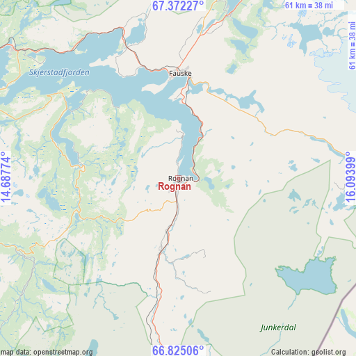
Rognan GPS coordinates[2]
67° 6' 0.756" North, 15° 23' 27.096" East
| Map corner | latitude | longitude |
|---|---|---|
| Upper-left | 67.37227°, | 14.68774° |
| Center: | 67.10021°, | 15.39086° |
| Lower-right: | 66.82506°, | 16.09399° |
| Map W x H: | 60.8×60.8 km | = 37.8×37.8mi |
| max Lat: | 71.04137° ⇑13% North |
| Rognan: | 67.10021° |
| min Lat: | ⇓87% South 58.0274° |
| min Long | Rognan | max Long |
| 4.71485° | 15.39086° | 31.11066° |
| W 90%⇐ | ⇒10% E |
Elevation
Elevation of Rognan is 1 m = 3 ft, and this is 103.2 m = 339 ft below average elevation for this country.
| Max E: |
897 m = 2943 ft | 100% |
| Avg. | 104.2 m = 342 ft | |
| Rognan | 1 m = 3 ft | |
Min E: |
1 m = 3 ft | 0% |
See also: Norway elevation on elevation.city.
Geographical zone
Rognan is located in North Frigid zone (between North Pole and Arctic Circle). Distance of this North polar circle is 59.7 km =37.1 mi to South.| Distance of | km | miles | from Rognan |
|---|---|---|---|
| North Pole | 2546.2 | 1582.1 | to North |
| Arctic Circle | 59.7 | 37.1 | to South |
| Tropic Cancer | 4854.9 | 3016.7 | to South |
| Equator | 7460.8 | 4635.9 | to South |


Nearby cities:
15 places around Rognan: (largest is in red/bold)
• Bodø
47 km =29.2 mi,  295°
295°
• Fauske
17.6 km =10.9 mi,  0°
0°
• Glomfjord
70.4 km =43.7 mi,  243°
243°
• Hauknes
107.9 km =67 mi,  212°
212°
• Inndyr
59.6 km =37 mi,  262°
262°
• Leinesfjorden
76.8 km =47.7 mi,  347°
347°
• Løding
35.9 km =22.3 mi,  308°
308°
• Løpsmarka
47 km =29.2 mi, 300°
• Mo i Rana
103.3 km =64.2 mi, 212°
• Moldjord
36.9 km =22.9 mi,  253°
253°
• Oppeid
109.9 km =68.3 mi, 4°
• Storforshei
86.1 km =53.5 mi, 206°
• Straumen
29 km =18 mi,  18°
18°
• Vågaholmen
101.3 km =62.9 mi, 244°
• Ørnes
77.6 km =48.2 mi, 250°
Sources, notices
• [Note1] Compared only with cities in Norway existing in our database
• [Src1] Map data: © OpenStreetMap contributors (CC-BY-SA)
• [Src2] Other city data from geonames.org with taken over terms of usage.
• [Src3] Geographical zone / Annual Mean Temperature by Robert A. Rohde @ Wikipedia
