Salyān geodata
Salyān (Mid Western) is a seat of a third-order administrative division; located in Nepal in Asia/Kathmandu (GMT+5.75) time zone. In our database, there are 62 cities with bigger population. Compared to other cities in Nepal, 74.3% of cities are located further ↓South; 77% of cities are located further →East and 73% of cities have lower elevation than Salyān. Note1


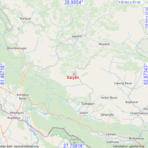
Salyān GPS coordinates[2]
28° 22' 42.888" North, 82° 10' 13.08" East
| Map corner | latitude | longitude |
|---|---|---|
| Upper-left | 28.9954°, | 81.46718° |
| Center: | 28.37858°, | 82.1703° |
| Lower-right: | 27.75816°, | 82.87343° |
| Map W x H: | 137.6×137.6 km | = 85.5×85.5mi |
| max Lat: | 30.04651° ⇑25.7% North |
| Salyān: | 28.37858° |
| min Lat: | ⇓74.3% South 26.45505° |
| min Long | Salyān | max Long |
| 80.17715° | 82.1703° | 88.09436° |
| W 23%⇐ | ⇒77% E |
Elevation
Elevation of Salyān is 1468 m = 4816 ft, and this is 292.8 m = 961 ft above average elevation for this country.
| Max E: |
5251 m = 17228 ft | 27% |
| Salyān | 1468 m 4816 ft | |
| Avg. | 1175.2 m = 3856 ft | |
Min E: |
72 m = 236 ft | 73% |
See also: Nepal elevation on elevation.city.
Geographical zone
Salyān is located in North temperate zone (between Tropic of Cancer and the Arctic Circle). Distance of this Northern Tropic circle is 549.5 km =341.4 mi to South.| Distance of | km | miles | from Salyān |
|---|---|---|---|
| North Pole | 6851.7 | 4257.4 | to North |
| Arctic Circle | 4245.8 | 2638.2 | to North |
| Tropic Cancer | 549.5 | 341.4 | to South |
| Equator | 3155.4 | 1960.7 | to South |


Nearby cities:
15 places around Salyān: (largest is in red/bold)
• Achhām
113 km =70.2 mi,  311°
311°
• Bardiyā
80.4 km =50 mi,  263°
263°
• Besisahar
28.7 km =17.8 mi,  124°
124°
• Bhojpur
62.6 km =38.9 mi,  218°
218°
• Birendranagar
58 km =36 mi,  295°
295°
• Butwāl
146.3 km =90.9 mi, 121°
• Bāglung
139.4 km =86.6 mi,  94°
94°
• Dailekh
68.6 km =42.6 mi,  319°
319°
• Gulariyā
83 km =51.6 mi, 256°
• Jumla
99.7 km =62 mi,  0°
0°
• Nepalgunj
65.4 km =40.6 mi,  236°
236°
• Pyūthān
77 km =47.8 mi,  114°
114°
• Surkhet
41.3 km =25.7 mi,  291°
291°
• Tulsīpur
30.2 km =18.8 mi,  155°
155°
• Ṭikāpur
104.2 km =64.7 mi,  279°
279°
Sources, notices
• [Note1] Compared only with cities in Nepal existing in our database
• [Src1] Map data: © OpenStreetMap contributors (CC-BY-SA)
• [Src2] Other city data from geonames.org with taken over terms of usage.
• [Src3] Geographical zone / Annual Mean Temperature by Robert A. Rohde @ Wikipedia
