Waitangi geodata
Waitangi (Chatham Islands) is a seat of a first-order administrative division; located in New Zealand in Pacific/Chatham (GMT+12.75) time zone. With population of 300 people, there are 205 cities with bigger population in this country. Compared to other cities in New Zealand, 84.1% of cities are located further ↑North; 100% of cities are located further →East and 67.6% of cities have higher elevation than Waitangi. Note1


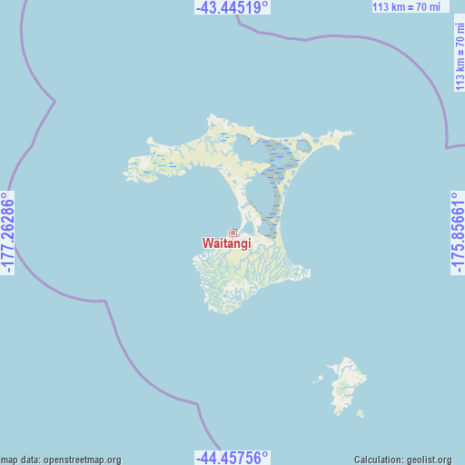
Waitangi GPS coordinates[2]
43° 57' 12.708" South, 176° 33' 35.028" West
| Map corner | latitude | longitude |
|---|---|---|
| Upper-left | -43.44519°, | -177.26286° |
| Center: | -43.95353°, | -176.55973° |
| Lower-right: | -44.45756°, | -175.85661° |
| Map W x H: | 112.6×112.6 km | = 70×70mi |
| max Lat: | -34.99604° ⇑84.1% North |
| Waitangi: | -43.95353° |
| min Lat: | ⇓15.9% South -46.6° |
| min Long | Waitangi | max Long |
| -176.55973° | -176.55973° | 178.33333° |
| W 0%⇐ | ⇒100% E |
Elevation
Elevation of Waitangi is 18 m = 59 ft, and this is 66.4 m = 218 ft below average elevation for this country.
| Max E: |
819 m = 2687 ft | 67.6% |
| Avg. | 84.4 m = 277 ft | |
| Waitangi | 18 m = 59 ft | |
Min E: |
3 m = 10 ft | 32.4% |
See also: New Zealand elevation on elevation.city.
Geographical zone
Waitangi is located in South temperate zone (between Tropic of Capricorn and the Antarctic Circle). Distance of this Southern Tropic circle is 2281.3 km =1417.5 mi to North.| Distance of | km | miles | from Waitangi |
|---|---|---|---|
| Equator | 4887.2 | 3036.8 | to North |
| Tropic Capricorn | 2281.3 | 1417.5 | to North |
| Antarctic Circle | 2514 | 1562.1 | to South |
| South Pole | 5119.9 | 3181.4 | to South |


Nearby cities:
15 places around Waitangi: (largest is in red/bold)
• Castlepoint
682.8 km =424.3 mi,  299°
299°
• Gisborne
743.6 km =462.1 mi,  322°
322°
• Hastings
726.7 km =451.6 mi,  311°
311°
• Linton Military Camp
757.8 km =470.9 mi, 301°
• Manutuke
745.4 km =463.2 mi, 321°
• Masterton
719.6 km =447.1 mi, 297°
• Napier
734.1 km =456.1 mi, 312°
• Otane
722.1 km =448.7 mi, 308°
• Takapau
729.8 km =453.5 mi, 306°
• Taradale
734.7 km =456.5 mi, 311°
• Tokomaru
758.7 km =471.4 mi, 300°
• Tolaga Bay
755.3 km =469.3 mi,  325°
325°
• Upper Hutt
754.7 km =468.9 mi,  294°
294°
• Waipawa
706.3 km =438.9 mi, 293°
• Wairoa
744.7 km =462.7 mi, 317°
Sources, notices
• [Note1] Compared only with cities in New Zealand existing in our database
• [Src1] Map data: © OpenStreetMap contributors (CC-BY-SA)
• [Src2] Other city data from geonames.org with taken over terms of usage.
• [Src3] Geographical zone / Annual Mean Temperature by Robert A. Rohde @ Wikipedia
