Nizwá geodata
Nizwá (Ad Dakhiliyah) is a seat of a first-order administrative division; located in Oman in Asia/Muscat (GMT+4) time zone. With population of 72,076 people, there are 11 cities with bigger population in this country. Compared to other cities in Oman, 74.2% of cities are located further ↑North; 61.3% of cities are located further ←West and 90.3% of cities have lower elevation than Nizwá. Note1


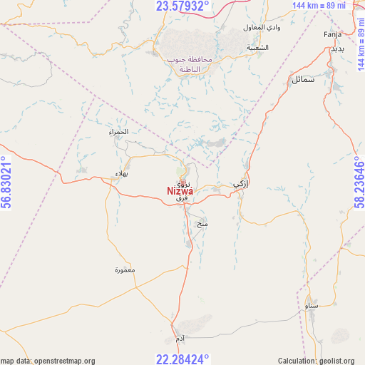
Nizwá GPS coordinates[2]
22° 55' 59.988" North, 57° 31' 59.988" East
| Map corner | latitude | longitude |
|---|---|---|
| Upper-left | 23.57932°, | 56.83021° |
| Center: | 22.93333°, | 57.53333° |
| Lower-right: | 22.28424°, | 58.23646° |
| Map W x H: | 144×144 km | = 89.5×89.5mi |
| max Lat: | 26.19778° ⇑74.2% North |
| Nizwá: | 22.93333° |
| min Lat: | ⇓25.8% South 17.01505° |
| min Long | Nizwá | max Long |
| 52.66042° | 57.53333° | 59.52889° |
| W 61.3%⇐ | ⇒38.7% E |
Elevation
Elevation of Nizwá is 511 m = 1677 ft, and this is 304.3 m = 998 ft above average elevation for this country.
| Max E: |
684 m = 2244 ft | 9.7% |
| Nizwá | 511 m 1677 ft | |
| Avg. | 206.7 m = 678 ft | |
Min E: |
1 m = 3 ft | 90.3% |
See also: Nizwá elevation on elevation.city.
Geographical zone
Nizwá is located in North Torrid zone (between Equator and Tropic of Cancer). Distance of this Northern Tropic circle is 56 km =34.8 mi to North.| Distance of | km | miles | from Nizwá |
|---|---|---|---|
| North Pole | 7457.1 | 4633.6 | to North |
| Arctic Circle | 4851.2 | 3014.4 | to North |
| Tropic Cancer | 56 | 34.8 | to North |
| Equator | 2549.9 | 1584.4 | to South |


Nearby cities:
15 places around Nizwá: (largest is in red/bold)
• Adam
61.6 km =38.3 mi,  180°
180°
• As Suwayq
102.3 km =63.6 mi,  354°
354°
• Bahlā’
23.9 km =14.9 mi,  282°
282°
• Barkā’
90.4 km =56.2 mi,  23°
23°
• Bawshar
113.9 km =70.8 mi,  51°
51°
• Bayt al ‘Awābī
41.1 km =25.5 mi,  358°
358°
• Bidbid
80.5 km =50 mi, 49°
• Ibrā’
106 km =65.9 mi,  104°
104°
• Izkī
23.9 km =14.9 mi,  90°
90°
• Muscat
115 km =71.5 mi, 50°
• Oman Smart Future City
80.3 km =49.9 mi,  4°
4°
• Rustaq
52.1 km =32.4 mi, 347°
• Seeb
105.8 km =65.7 mi,  39°
39°
• Sufālat Samā’il
65.3 km =40.6 mi, 49°
• ‘Ibrī
109.1 km =67.8 mi,  287°
287°
Sources, notices
• [Note1] Compared only with cities in Oman existing in our database
• [Src1] Map data: © OpenStreetMap contributors (CC-BY-SA)
• [Src2] Other city data from geonames.org with taken over terms of usage.
• [Src3] Geographical zone / Annual Mean Temperature by Robert A. Rohde @ Wikipedia
