Bawshar geodata
Bawshar (Muscat) is a populated place; located in Oman in Asia/Muscat (GMT+4) time zone. With population of 159,487 people, there are 3 cities with bigger population in this country. Compared to other cities in Oman, 51.6% of cities are located further ↓South; 83.9% of cities are located further ←West and 58.1% of cities have higher elevation than Bawshar. Note1


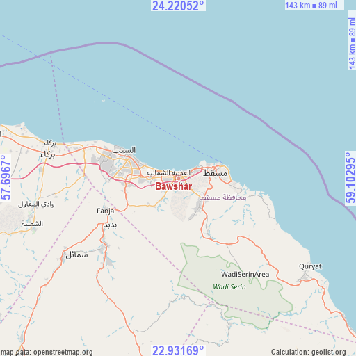
Bawshar GPS coordinates[2]
23° 34' 39.684" North, 58° 23' 59.352" East
| Map corner | latitude | longitude |
|---|---|---|
| Upper-left | 24.22052°, | 57.6967° |
| Center: | 23.57769°, | 58.39982° |
| Lower-right: | 22.93169°, | 59.10295° |
| Map W x H: | 143.3×143.3 km | = 89×89mi |
| max Lat: | 26.19778° ⇑48.4% North |
| Bawshar: | 23.57769° |
| min Lat: | ⇓51.6% South 17.01505° |
| min Long | Bawshar | max Long |
| 52.66042° | 58.39982° | 59.52889° |
| W 83.9%⇐ | ⇒16.1% E |
Elevation
Elevation of Bawshar is 15 m = 49 ft, and this is 191.7 m = 629 ft below average elevation for this country.
| Max E: |
684 m = 2244 ft | 58.1% |
| Avg. | 206.7 m = 678 ft | |
| Bawshar | 15 m = 49 ft | |
Min E: |
1 m = 3 ft | 41.9% |
See also: Bawshar elevation on elevation.city.
Geographical zone
Bawshar is located in North temperate zone (between Tropic of Cancer and the Arctic Circle). Distance of this Northern Tropic circle is 15.7 km =9.8 mi to South.| Distance of | km | miles | from Bawshar |
|---|---|---|---|
| North Pole | 7385.5 | 4589.1 | to North |
| Arctic Circle | 4779.6 | 2969.9 | to North |
| Tropic Cancer | 15.7 | 9.8 | to South |
| Equator | 2621.6 | 1629 | to South |


Nearby cities:
15 places around Bawshar: (largest is in red/bold)
• Al Qābil
115.9 km =72 mi,  164°
164°
• As Suwayq
102.4 km =63.6 mi,  287°
287°
• Badīyah
131.9 km =82 mi, 161°
• Bahlā’
130.2 km =80.9 mi,  239°
239°
• Barkā’
53.5 km =33.2 mi,  282°
282°
• Bayt al ‘Awābī
94.4 km =58.7 mi,  251°
251°
• Bidbid
33.5 km =20.8 mi, 235°
• Ibrā’
99.6 km =61.9 mi,  172°
172°
• Izkī
96.5 km =60 mi,  222°
222°
• Muscat
1.1 km =0.7 mi,  48°
48°
• Nizwá
113.9 km =70.8 mi,  231°
231°
• Oman Smart Future City
82 km =51 mi, 275°
• Rustaq
101.6 km =63.1 mi,  258°
258°
• Seeb
23.8 km =14.8 mi,  295°
295°
• Sufālat Samā’il
48.7 km =30.3 mi, 233°
Sources, notices
• [Note1] Compared only with cities in Oman existing in our database
• [Src1] Map data: © OpenStreetMap contributors (CC-BY-SA)
• [Src2] Other city data from geonames.org with taken over terms of usage.
• [Src3] Geographical zone / Annual Mean Temperature by Robert A. Rohde @ Wikipedia
