Rustaq geodata
Rustaq (Al Batinah South) is a populated place; located in Oman in Asia/Muscat (GMT+4) time zone. With population of 79,383 people, there are 9 cities with bigger population in this country. Compared to other cities in Oman, 54.8% of cities are located further ↑North; 51.6% of cities are located further →East and 67.7% of cities have lower elevation than Rustaq. Note1


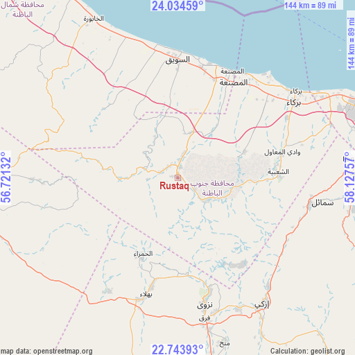
Rustaq GPS coordinates[2]
23° 23' 26.988" North, 57° 25' 27.984" East
| Map corner | latitude | longitude |
|---|---|---|
| Upper-left | 24.03459°, | 56.72132° |
| Center: | 23.39083°, | 57.42444° |
| Lower-right: | 22.74393°, | 58.12757° |
| Map W x H: | 143.5×143.5 km | = 89.2×89.2mi |
| max Lat: | 26.19778° ⇑54.8% North |
| Rustaq: | 23.39083° |
| min Lat: | ⇓45.2% South 17.01505° |
| min Long | Rustaq | max Long |
| 52.66042° | 57.42444° | 59.52889° |
| W 48.4%⇐ | ⇒51.6% E |
Elevation
Elevation of Rustaq is 341 m = 1119 ft, and this is 134.3 m = 441 ft above average elevation for this country.
| Max E: |
684 m = 2244 ft | 32.3% |
| Rustaq | 341 m 1119 ft | |
| Avg. | 206.7 m = 678 ft | |
Min E: |
1 m = 3 ft | 67.7% |
See also: Rustaq elevation on elevation.city.
Geographical zone
Rustaq is located in North Torrid zone (between Equator and Tropic of Cancer). Distance of this Northern Tropic circle is 5.1 km =3.2 mi to North.| Distance of | km | miles | from Rustaq |
|---|---|---|---|
| North Pole | 7406.2 | 4602 | to North |
| Arctic Circle | 4800.4 | 2982.8 | to North |
| Tropic Cancer | 5.1 | 3.2 | to North |
| Equator | 2600.8 | 1616.1 | to South |


Nearby cities:
15 places around Rustaq: (largest is in red/bold)
• Al Khābūrah
72.8 km =45.2 mi,  332°
332°
• As Suwayq
51 km =31.7 mi,  1°
1°
• Bahlā’
47.4 km =29.5 mi,  194°
194°
• Barkā’
56.9 km =35.4 mi,  55°
55°
• Bawshar
101.6 km =63.1 mi,  78°
78°
• Bayt al ‘Awābī
14.1 km =8.8 mi,  133°
133°
• Bidbid
71.9 km =44.7 mi,  88°
88°
• Izkī
61.7 km =38.3 mi,  145°
145°
• Muscat
102.6 km =63.8 mi, 77°
• Nizwá
52.1 km =32.4 mi,  167°
167°
• Oman Smart Future City
34.1 km =21.2 mi,  31°
31°
• Seeb
83.9 km =52.1 mi,  68°
68°
• Sufālat Samā’il
61 km =37.9 mi,  97°
97°
• Yanqul
92.8 km =57.7 mi,  283°
283°
• ‘Ibrī
94.6 km =58.8 mi,  258°
258°
Sources, notices
• [Note1] Compared only with cities in Oman existing in our database
• [Src1] Map data: © OpenStreetMap contributors (CC-BY-SA)
• [Src2] Other city data from geonames.org with taken over terms of usage.
• [Src3] Geographical zone / Annual Mean Temperature by Robert A. Rohde @ Wikipedia
