Muscat geodata
Muscat is a capital of a political entity; located in Oman in Asia/Muscat (GMT+4) time zone. With population of 797,000 people, there are 0 cities with bigger population in this country. Compared to other cities in Oman, 54.8% of cities are located further ↓South; 87.1% of cities are located further ←West and 64.5% of cities have higher elevation than Muscat. Note1


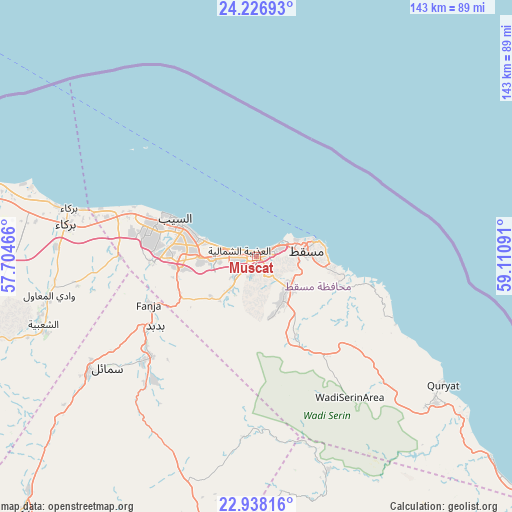
Muscat GPS coordinates[2]
23° 35' 2.868" North, 58° 24' 28.008" East
| Map corner | latitude | longitude |
|---|---|---|
| Upper-left | 24.22693°, | 57.70466° |
| Center: | 23.58413°, | 58.40778° |
| Lower-right: | 22.93816°, | 59.11091° |
| Map W x H: | 143.3×143.3 km | = 89×89mi |
| max Lat: | 26.19778° ⇑45.2% North |
| Muscat: | 23.58413° |
| min Lat: | ⇓54.8% South 17.01505° |
| min Long | Muscat | max Long |
| 52.66042° | 58.40778° | 59.52889° |
| W 87.1%⇐ | ⇒12.9% E |
Elevation
Elevation of Muscat is 14 m = 46 ft, and this is 192.7 m = 632 ft below average elevation for this country.
| Max E: |
684 m = 2244 ft | 64.5% |
| Avg. | 206.7 m = 678 ft | |
| Muscat | 14 m = 46 ft | |
Min E: |
1 m = 3 ft | 35.5% |
See also: Muscat elevation on elevation.city.
Geographical zone
Muscat is located in North temperate zone (between Tropic of Cancer and the Arctic Circle). Distance of this Northern Tropic circle is 16.4 km =10.2 mi to South.| Distance of | km | miles | from Muscat |
|---|---|---|---|
| North Pole | 7384.8 | 4588.7 | to North |
| Arctic Circle | 4778.9 | 2969.5 | to North |
| Tropic Cancer | 16.4 | 10.2 | to South |
| Equator | 2622.3 | 1629.4 | to South |


Nearby cities:
15 places around Muscat: (largest is in red/bold)
• Al Qābil
116.4 km =72.3 mi,  165°
165°
• As Suwayq
103 km =64 mi,  286°
286°
• Badīyah
132.3 km =82.2 mi,  162°
162°
• Bahlā’
131.2 km =81.5 mi,  239°
239°
• Barkā’
54.2 km =33.7 mi,  281°
281°
• Bawshar
1.1 km =0.7 mi,  228°
228°
• Bayt al ‘Awābī
95.4 km =59.3 mi,  250°
250°
• Bidbid
34.6 km =21.5 mi, 235°
• Ibrā’
100.2 km =62.3 mi, 172°
• Izkī
97.6 km =60.6 mi,  222°
222°
• Nizwá
115 km =71.5 mi, 230°
• Oman Smart Future City
82.7 km =51.4 mi, 275°
• Rustaq
102.6 km =63.8 mi,  257°
257°
• Seeb
24.2 km =15 mi, 293°
• Sufālat Samā’il
49.8 km =30.9 mi, 233°
In other languages:
- In Spanish: Mascate
- In France: Mascate
- In German: Maskat
- In Italian: Muscat, Mascate
- In Russian: Маскат
- In Chinese: 马斯喀特
Sources, notices
• [Note1] Compared only with cities in Oman existing in our database
• [Src1] Map data: © OpenStreetMap contributors (CC-BY-SA)
• [Src2] Other city data from geonames.org with taken over terms of usage.
• [Src3] Geographical zone / Annual Mean Temperature by Robert A. Rohde @ Wikipedia
