Barkā’ geodata
Barkā’ (Al Batinah South) is a section of populated place; located in Oman in Asia/Muscat (GMT+4) time zone. With population of 81,647 people, there are 8 cities with bigger population in this country. Compared to other cities in Oman, 67.7% of cities are located further ↓South; 71% of cities are located further ←West and 64.5% of cities have higher elevation than Barkā’. Note1


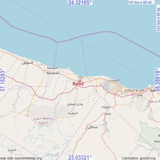
Barkā’ GPS coordinates[2]
23° 40' 43.392" North, 57° 53' 9.78" East
| Map corner | latitude | longitude |
|---|---|---|
| Upper-left | 24.32105°, | 57.18293° |
| Center: | 23.67872°, | 57.88605° |
| Lower-right: | 23.03321°, | 58.58918° |
| Map W x H: | 143.2×143.2 km | = 89×89mi |
| max Lat: | 26.19778° ⇑32.3% North |
| Barkā’: | 23.67872° |
| min Lat: | ⇓67.7% South 17.01505° |
| min Long | Barkā’ | max Long |
| 52.66042° | 57.88605° | 59.52889° |
| W 71%⇐ | ⇒29% E |
Elevation
Elevation of Barkā’ is 14 m = 46 ft, and this is 192.7 m = 632 ft below average elevation for this country.
| Max E: |
684 m = 2244 ft | 64.5% |
| Avg. | 206.7 m = 678 ft | |
| Barkā’ | 14 m = 46 ft | |
Min E: |
1 m = 3 ft | 35.5% |
See also: Barkā’ elevation on elevation.city.
Geographical zone
Barkā’ is located in North temperate zone (between Tropic of Cancer and the Arctic Circle). Distance of this Northern Tropic circle is 26.9 km =16.7 mi to South.| Distance of | km | miles | from Barkā’ |
|---|---|---|---|
| North Pole | 7374.2 | 4582.1 | to North |
| Arctic Circle | 4768.3 | 2962.9 | to North |
| Tropic Cancer | 26.9 | 16.7 | to South |
| Equator | 2632.8 | 1635.9 | to South |


Nearby cities:
15 places around Barkā’: (largest is in red/bold)
• Al Khābūrah
87 km =54.1 mi,  291°
291°
• As Suwayq
49.3 km =30.6 mi, 292°
• Bahlā’
97.9 km =60.8 mi,  217°
217°
• Bawshar
53.5 km =33.2 mi,  102°
102°
• Bayt al ‘Awābī
55.7 km =34.6 mi, 221°
• Bidbid
38.9 km =24.2 mi,  140°
140°
• Ibrā’
128.3 km =79.7 mi,  148°
148°
• Izkī
83.8 km =52.1 mi,  188°
188°
• Muscat
54.2 km =33.7 mi, 101°
• Nizwá
90.4 km =56.2 mi,  203°
203°
• Oman Smart Future City
29.3 km =18.2 mi,  264°
264°
• Rustaq
56.9 km =35.4 mi,  235°
235°
• Seeb
30.9 km =19.2 mi,  91°
91°
• Sufālat Samā’il
42.4 km =26.3 mi,  161°
161°
• Şaḩam
115.3 km =71.6 mi,  298°
298°
Sources, notices
• [Note1] Compared only with cities in Oman existing in our database
• [Src1] Map data: © OpenStreetMap contributors (CC-BY-SA)
• [Src2] Other city data from geonames.org with taken over terms of usage.
• [Src3] Geographical zone / Annual Mean Temperature by Robert A. Rohde @ Wikipedia
