Ibrā’ geodata
Ibrā’ (Northeastern Governorate) is a seat of a first-order administrative division; located in Oman in Asia/Muscat (GMT+4) time zone. With population of 25,265 people, there are 19 cities with bigger population in this country. Compared to other cities in Oman, 77.4% of cities are located further ↑North; 90.3% of cities are located further ←West and 80.6% of cities have lower elevation than Ibrā’. Note1


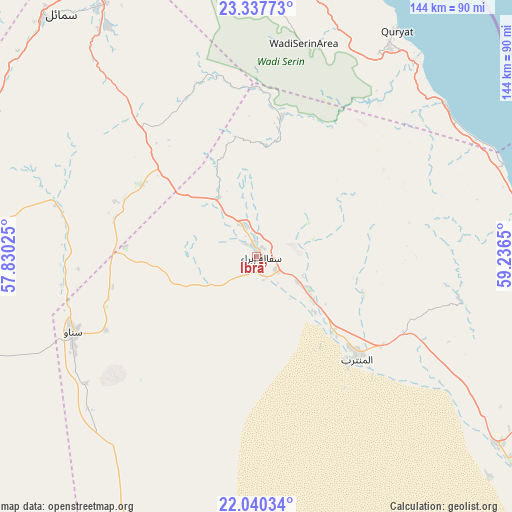
Ibrā’ GPS coordinates[2]
22° 41' 26.052" North, 58° 32' 0.132" East
| Map corner | latitude | longitude |
|---|---|---|
| Upper-left | 23.33773°, | 57.83025° |
| Center: | 22.69057°, | 58.53337° |
| Lower-right: | 22.04034°, | 59.2365° |
| Map W x H: | 144.3×144.3 km | = 89.7×89.7mi |
| max Lat: | 26.19778° ⇑77.4% North |
| Ibrā’: | 22.69057° |
| min Lat: | ⇓22.6% South 17.01505° |
| min Long | Ibrā’ | max Long |
| 52.66042° | 58.53337° | 59.52889° |
| W 90.3%⇐ | ⇒9.7% E |
Elevation
Elevation of Ibrā’ is 446 m = 1463 ft, and this is 239.3 m = 785 ft above average elevation for this country.
| Max E: |
684 m = 2244 ft | 19.4% |
| Ibrā’ | 446 m 1463 ft | |
| Avg. | 206.7 m = 678 ft | |
Min E: |
1 m = 3 ft | 80.6% |
See also: Oman elevation on elevation.city.
Geographical zone
Ibrā’ is located in North Torrid zone (between Equator and Tropic of Cancer). Distance of this Northern Tropic circle is 83 km =51.6 mi to North.| Distance of | km | miles | from Ibrā’ |
|---|---|---|---|
| North Pole | 7484.1 | 4650.4 | to North |
| Arctic Circle | 4878.2 | 3031.2 | to North |
| Tropic Cancer | 83 | 51.6 | to North |
| Equator | 2523 | 1567.7 | to South |


Nearby cities:
15 places around Ibrā’: (largest is in red/bold)
• Adam
109 km =67.7 mi,  251°
251°
• Al Qābil
21.2 km =13.2 mi,  128°
128°
• Badīyah
38.3 km =23.8 mi, 134°
• Bahlā’
129.9 km =80.7 mi,  284°
284°
• Barkā’
128.3 km =79.7 mi,  328°
328°
• Bawshar
99.6 km =61.9 mi,  352°
352°
• Bayt al ‘Awābī
123.7 km =76.9 mi,  303°
303°
• Bidbid
89.9 km =55.9 mi, 332°
• Izkī
83.1 km =51.6 mi,  288°
288°
• Muscat
100.2 km =62.3 mi, 352°
• Nizwá
106 km =65.9 mi, 284°
• Rustaq
137.6 km =85.5 mi, 304°
• Seeb
114.5 km =71.1 mi,  342°
342°
• Sufālat Samā’il
87.4 km =54.3 mi,  322°
322°
• Sur
103.1 km =64.1 mi,  97°
97°
Sources, notices
• [Note1] Compared only with cities in Oman existing in our database
• [Src1] Map data: © OpenStreetMap contributors (CC-BY-SA)
• [Src2] Other city data from geonames.org with taken over terms of usage.
• [Src3] Geographical zone / Annual Mean Temperature by Robert A. Rohde @ Wikipedia
