Cerro Punta geodata
Cerro Punta (Chiriquí) is a seat of a third-order administrative division; located in Panama in America/Panama (GMT-5) time zone. With population of 1,568 people, there are 150 cities with bigger population in this country. Compared to other cities in Panama, 76.7% of cities are located further ↓South; 90.9% of cities are located further →East and 99.9% of cities have lower elevation than Cerro Punta. Note1


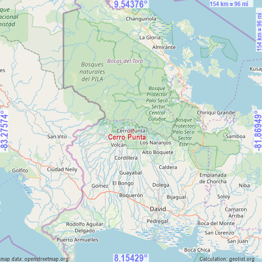
Cerro Punta GPS coordinates[2]
8° 50' 58.848" North, 82° 34' 21.396" West
| Map corner | latitude | longitude |
|---|---|---|
| Upper-left | 9.54376°, | -83.27574° |
| Center: | 8.84968°, | -82.57261° |
| Lower-right: | 8.15429°, | -81.86949° |
| Map W x H: | 154.5×154.5 km | = 96×96mi |
| max Lat: | 9.60898° ⇑23.3% North |
| Cerro Punta: | 8.84968° |
| min Lat: | ⇓76.7% South 7.26534° |
| min Long | Cerro Punta | max Long |
| -82.91275° | -82.57261° | -77.38965° |
| W 9.1%⇐ | ⇒90.9% E |
Elevation
Elevation of Cerro Punta is 2021 m = 6631 ft, and this is 1848.9 m = 6066 ft above average elevation for this country.
| Max E: |
2103 m = 6900 ft | 0.099999999999994% |
| Cerro Punta | 2021 m 6631 ft | |
| Avg. | 172.1 m = 565 ft | |
Min E: |
-1 m = -3 ft | 99.9% |
See also: Panama elevation on elevation.city.
Geographical zone
Cerro Punta is located in North Torrid zone (between Equator and Tropic of Cancer). Distance of Equator is 984 km =611.4 mi to South.| Distance of | km | miles | from Cerro Punta |
|---|---|---|---|
| North Pole | 9023.1 | 5606.7 | to North |
| Arctic Circle | 6417.2 | 3987.5 | to North |
| Tropic Cancer | 1621.9 | 1007.8 | to North |
| Equator | 984 | 611.4 | to South |


Nearby cities:
15 places around Cerro Punta: (largest is in red/bold)
• Alto Boquete
20.1 km =12.5 mi,  129°
129°
• Alto Lino
16.1 km =10 mi,  110°
110°
• Alto Quiel
11.9 km =7.4 mi, 114°
• Bajo Boquete
17.7 km =11 mi,  119°
119°
• Barrio Guadalupe
1.9 km =1.2 mi,  25°
25°
• Boquete
16.4 km =10.2 mi, 118°
• Cordillera
16.2 km =10.1 mi,  191°
191°
• El Banco
18.7 km =11.6 mi,  159°
159°
• Jaramillo Arriba
17.3 km =10.7 mi, 109°
• Los Naranjos
15.2 km =9.4 mi, 114°
• Palmira
17.9 km =11.1 mi,  135°
135°
• Palmira Centro
18 km =11.2 mi, 132°
• Piedra Candela
20.2 km =12.6 mi,  279°
279°
• Potrerillos Arriba
20.3 km =12.6 mi,  153°
153°
• Volcán
11.2 km =7 mi,  220°
220°
Sources, notices
• [Note1] Compared only with cities in Panama existing in our database
• [Src1] Map data: © OpenStreetMap contributors (CC-BY-SA)
• [Src2] Other city data from geonames.org with taken over terms of usage.
• [Src3] Geographical zone / Annual Mean Temperature by Robert A. Rohde @ Wikipedia
