Barnizal geodata
Barnizal (Veraguas) is a seat of a third-order administrative division; located in Panama in America/Panama (GMT-5) time zone. With population of 74 people, there are 675 cities with bigger population in this country. Compared to other cities in Panama, 56.9% of cities are located further ↑North; 56.3% of cities are located further →East and 86.4% of cities have lower elevation than Barnizal. Note1


Barnizal GPS coordinates[2]
8° 24' 16.56" North, 80° 46' 39.54" West
| Map corner | latitude | longitude |
|---|---|---|
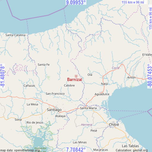
| Upper-left | 9.09953°, | -81.48078° |
| Center: | 8.4046°, | -80.77765° |
| Lower-right: | 7.70842°, | -80.07453° |
| Map W x H: | 154.7×154.7 km | = 96.1×96.1mi |
| max Lat: | 9.60898° ⇑56.9% North |
| Barnizal: | 8.4046° |
| min Lat: | ⇓43.1% South 7.26534° |
| min Long | Barnizal | max Long |
| -82.91275° | -80.77765° | -77.38965° |
| W 43.7%⇐ | ⇒56.3% E |
Elevation
Elevation of Barnizal is 367 m = 1204 ft, and this is 194.9 m = 639 ft above average elevation for this country.
| Max E: |
2103 m = 6900 ft | 13.6% |
| Barnizal | 367 m 1204 ft | |
| Avg. | 172.1 m = 565 ft | |
Min E: |
-1 m = -3 ft | 86.4% |
See also: Panama elevation on elevation.city.
Geographical zone
Barnizal is located in North Torrid zone (between Equator and Tropic of Cancer). Distance of Equator is 934.5 km =580.7 mi to South.| Distance of | km | miles | from Barnizal |
|---|---|---|---|
| North Pole | 9072.6 | 5637.5 | to North |
| Arctic Circle | 6466.7 | 4018.2 | to North |
| Tropic Cancer | 1671.4 | 1038.6 | to North |
| Equator | 934.5 | 580.7 | to South |


Nearby cities:
15 places around Barnizal: (largest is in red/bold)
• Barranco Colorado
15.7 km =9.8 mi,  96°
96°
• Boquerón
20 km =12.4 mi,  206°
206°
• Calobre
11.8 km =7.3 mi,  216°
216°
• El Coclá
18.3 km =11.4 mi,  239°
239°
• El Copé
11.4 km =7.1 mi,  71°
71°
• El Potrero
3.6 km =2.2 mi, 210°
• La Laguna
9 km =5.6 mi,  144°
144°
• La Yeguada
9.2 km =5.7 mi,  288°
288°
• Las Huacas del Quije
7.5 km =4.7 mi,  22°
22°
• Monjarás
10.5 km =6.5 mi,  248°
248°
• Nuestro Amo
21.2 km =13.2 mi,  77°
77°
• Olá
14 km =8.7 mi, 83°
• Piedras Gordas
19.8 km =12.3 mi,  312°
312°
• San José
7.6 km =4.7 mi,  336°
336°
• Toza
16.5 km =10.3 mi,  113°
113°
Sources, notices
• [Note1] Compared only with cities in Panama existing in our database
• [Src1] Map data: © OpenStreetMap contributors (CC-BY-SA)
• [Src2] Other city data from geonames.org with taken over terms of usage.
• [Src3] Geographical zone / Annual Mean Temperature by Robert A. Rohde @ Wikipedia
