Nutiví geodata
Nutiví (Ngöbe-Buglé) is a populated place; located in Panama in America/Panama (GMT-5) time zone. With population of 546 people, there are 447 cities with bigger population in this country. Compared to other cities in Panama, 78.2% of cities are located further ↓South; 76.1% of cities are located further →East and 85.5% of cities have higher elevation than Nutiví. Note1


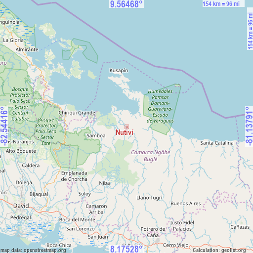
Nutiví GPS coordinates[2]
8° 52' 14.304" North, 81° 50' 27.708" West
| Map corner | latitude | longitude |
|---|---|---|
| Upper-left | 9.56468°, | -82.54416° |
| Center: | 8.87064°, | -81.84103° |
| Lower-right: | 8.17528°, | -81.13791° |
| Map W x H: | 154.5×154.5 km | = 96×96mi |
| max Lat: | 9.60898° ⇑21.8% North |
| Nutiví: | 8.87064° |
| min Lat: | ⇓78.2% South 7.26534° |
| min Long | Nutiví | max Long |
| -82.91275° | -81.84103° | -77.38965° |
| W 23.9%⇐ | ⇒76.1% E |
Elevation
Elevation of Nutiví is 17 m = 56 ft, and this is 155.1 m = 509 ft below average elevation for this country.
| Max E: |
2103 m = 6900 ft | 85.5% |
| Avg. | 172.1 m = 565 ft | |
| Nutiví | 17 m = 56 ft | |
Min E: |
-1 m = -3 ft | 14.5% |
See also: Panama elevation on elevation.city.
Geographical zone
Nutiví is located in North Torrid zone (between Equator and Tropic of Cancer). Distance of Equator is 986.3 km =612.9 mi to South.| Distance of | km | miles | from Nutiví |
|---|---|---|---|
| North Pole | 9020.7 | 5605.2 | to North |
| Arctic Circle | 6414.9 | 3986 | to North |
| Tropic Cancer | 1619.6 | 1006.4 | to North |
| Equator | 986.3 | 612.9 | to South |


Nearby cities:
15 places around Nutiví: (largest is in red/bold)
• Bahía Azul
30.7 km =19.1 mi,  349°
349°
• Bisira
3.1 km =1.9 mi,  333°
333°
• Boca del Río Chiriquí
29.6 km =18.4 mi,  95°
95°
• Cascabel
38.4 km =23.9 mi,  185°
185°
• Cayo de Agua
39 km =24.2 mi,  322°
322°
• Chiriquí Grande
31.5 km =19.6 mi,  285°
285°
• Cuoronte
22.6 km =14 mi,  164°
164°
• Kankintú
4.2 km =2.6 mi,  136°
136°
• Kusapín
34.5 km =21.4 mi, 351°
• Mirones
37 km =23 mi, 159°
• Piedra Roja
35 km =21.7 mi, 162°
• Punta Peña
38.1 km =23.7 mi,  277°
277°
• Quebrada Tula
17.4 km =10.8 mi,  258°
258°
• Rámbala
37.7 km =23.4 mi, 278°
• Tobobe
27.9 km =17.3 mi,  3°
3°
Sources, notices
• [Note1] Compared only with cities in Panama existing in our database
• [Src1] Map data: © OpenStreetMap contributors (CC-BY-SA)
• [Src2] Other city data from geonames.org with taken over terms of usage.
• [Src3] Geographical zone / Annual Mean Temperature by Robert A. Rohde @ Wikipedia
