Punta Peña geodata
Punta Peña (Bocas del Toro) is a seat of a third-order administrative division; located in Panama in America/Panama (GMT-5) time zone. With population of 1,187 people, there are 205 cities with bigger population in this country. Compared to other cities in Panama, 79.6% of cities are located further ↓South; 80.6% of cities are located further →East and 75.7% of cities have higher elevation than Punta Peña. Note1


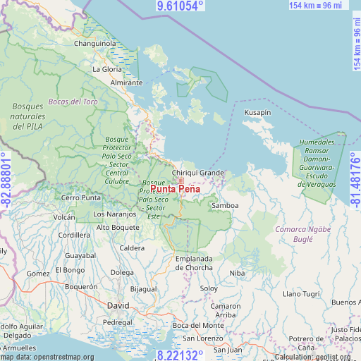
Punta Peña GPS coordinates[2]
8° 54' 59.724" North, 82° 11' 5.568" West
| Map corner | latitude | longitude |
|---|---|---|
| Upper-left | 9.61054°, | -82.88801° |
| Center: | 8.91659°, | -82.18488° |
| Lower-right: | 8.22132°, | -81.48176° |
| Map W x H: | 154.5×154.5 km | = 96×96mi |
| max Lat: | 9.60898° ⇑20.4% North |
| Punta Peña: | 8.91659° |
| min Lat: | ⇓79.6% South 7.26534° |
| min Long | Punta Peña | max Long |
| -82.91275° | -82.18488° | -77.38965° |
| W 19.4%⇐ | ⇒80.6% E |
Elevation
Elevation of Punta Peña is 29 m = 95 ft, and this is 143.1 m = 469 ft below average elevation for this country.
| Max E: |
2103 m = 6900 ft | 75.7% |
| Avg. | 172.1 m = 565 ft | |
| Punta Peña | 29 m = 95 ft | |
Min E: |
-1 m = -3 ft | 24.3% |
See also: Panama elevation on elevation.city.
Geographical zone
Punta Peña is located in North Torrid zone (between Equator and Tropic of Cancer). Distance of Equator is 991.4 km =616 mi to South.| Distance of | km | miles | from Punta Peña |
|---|---|---|---|
| North Pole | 9015.6 | 5602 | to North |
| Arctic Circle | 6409.7 | 3982.8 | to North |
| Tropic Cancer | 1614.5 | 1003.2 | to North |
| Equator | 991.4 | 616 | to South |


Nearby cities:
15 places around Punta Peña: (largest is in red/bold)
• Alto Lino
30.4 km =18.9 mi,  244°
244°
• Cauchero
27.6 km =17.1 mi,  341°
341°
• Cayo de Agua
29.6 km =18.4 mi,  28°
28°
• Chiriquí Grande
8.1 km =5 mi,  66°
66°
• Jaramillo Arriba
29.4 km =18.3 mi, 243°
• Los Chiricanos
7.6 km =4.7 mi,  334°
334°
• Miramar
10.7 km =6.6 mi,  324°
324°
• Norteño
17.2 km =10.7 mi,  303°
303°
• Paja de Sombrero
29.8 km =18.5 mi,  209°
209°
• Pueblo Nuevo
5.9 km =3.7 mi,  227°
227°
• Punta Laurel
25.7 km =16 mi,  14°
14°
• Punta Róbalo
15.1 km =9.4 mi, 331°
• Quebrada Tula
22.4 km =13.9 mi,  112°
112°
• Rámbala
0.6 km =0.4 mi,  47°
47°
• Valle de La Mina
28.5 km =17.7 mi,  190°
190°
Sources, notices
• [Note1] Compared only with cities in Panama existing in our database
• [Src1] Map data: © OpenStreetMap contributors (CC-BY-SA)
• [Src2] Other city data from geonames.org with taken over terms of usage.
• [Src3] Geographical zone / Annual Mean Temperature by Robert A. Rohde @ Wikipedia
