Chiriquí Grande geodata
Chiriquí Grande (Bocas del Toro) is a seat of a second-order administrative division; located in Panama in America/Panama (GMT-5) time zone. With population of 1,525 people, there are 153 cities with bigger population in this country. Compared to other cities in Panama, 81.1% of cities are located further ↓South; 79.8% of cities are located further →East and 70.7% of cities have higher elevation than Chiriquí Grande. Note1


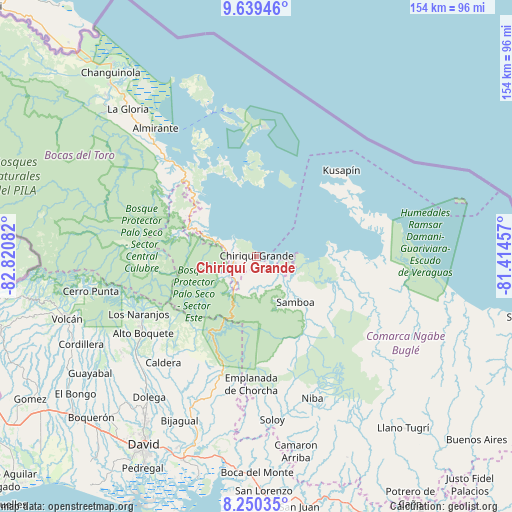
Chiriquí Grande GPS coordinates[2]
8° 56' 44.052" North, 82° 7' 3.684" West
| Map corner | latitude | longitude |
|---|---|---|
| Upper-left | 9.63946°, | -82.82082° |
| Center: | 8.94557°, | -82.11769° |
| Lower-right: | 8.25035°, | -81.41457° |
| Map W x H: | 154.5×154.5 km | = 96×96mi |
| max Lat: | 9.60898° ⇑18.9% North |
| Chiriquí Grande: | 8.94557° |
| min Lat: | ⇓81.1% South 7.26534° |
| min Long | Chiriquí Grand | max Long |
| -82.91275° | -82.11769° | -77.38965° |
| W 20.2%⇐ | ⇒79.8% E |
Elevation
Elevation of Chiriquí Grande is 35 m = 115 ft, and this is 137.1 m = 450 ft below average elevation for this country.
| Max E: |
2103 m = 6900 ft | 70.7% |
| Avg. | 172.1 m = 565 ft | |
| Chiriquí Grande | 35 m = 115 ft | |
Min E: |
-1 m = -3 ft | 29.3% |
See also: Panama elevation on elevation.city.
Geographical zone
Chiriquí Grande is located in North Torrid zone (between Equator and Tropic of Cancer). Distance of Equator is 994.7 km =618.1 mi to South.| Distance of | km | miles | from Chiriquí Grande |
|---|---|---|---|
| North Pole | 9012.4 | 5600 | to North |
| Arctic Circle | 6406.5 | 3980.8 | to North |
| Tropic Cancer | 1611.3 | 1001.2 | to North |
| Equator | 994.7 | 618.1 | to South |


Nearby cities:
15 places around Chiriquí Grande: (largest is in red/bold)
• Bahía Azul
32.8 km =20.4 mi,  48°
48°
• Bisira
29.5 km =18.3 mi,  100°
100°
• Cauchero
28.1 km =17.5 mi,  324°
324°
• Cayo de Agua
23.8 km =14.8 mi,  16°
16°
• Isla Tigre
25.8 km =16 mi,  9°
9°
• Los Chiricanos
11.2 km =7 mi,  288°
288°
• Miramar
14.7 km =9.1 mi, 291°
• Norteño
22.6 km =14 mi, 286°
• Nutiví
31.5 km =19.6 mi,  105°
105°
• Pueblo Nuevo
13.7 km =8.5 mi,  238°
238°
• Punta Laurel
21.8 km =13.5 mi,  357°
357°
• Punta Peña
8.1 km =5 mi,  246°
246°
• Punta Róbalo
17.6 km =10.9 mi,  304°
304°
• Quebrada Tula
17.7 km =11 mi,  131°
131°
• Rámbala
7.5 km =4.7 mi, 247°
Sources, notices
• [Note1] Compared only with cities in Panama existing in our database
• [Src1] Map data: © OpenStreetMap contributors (CC-BY-SA)
• [Src2] Other city data from geonames.org with taken over terms of usage.
• [Src3] Geographical zone / Annual Mean Temperature by Robert A. Rohde @ Wikipedia
