Cucunatí geodata
Cucunatí (Darién) is a seat of a third-order administrative division; located in Panama in America/Panama (GMT-5) time zone. With population of 537 people, there are 452 cities with bigger population in this country. Compared to other cities in Panama, 62% of cities are located further ↓South; 94.5% of cities are located further ←West and 87.3% of cities have higher elevation than Cucunatí. Note1


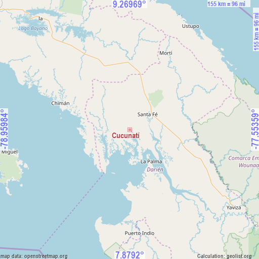
Cucunatí GPS coordinates[2]
8° 34' 30.288" North, 78° 15' 24.156" West
| Map corner | latitude | longitude |
|---|---|---|
| Upper-left | 9.26969°, | -78.95984° |
| Center: | 8.57508°, | -78.25671° |
| Lower-right: | 7.8792°, | -77.55359° |
| Map W x H: | 154.6×154.6 km | = 96.1×96.1mi |
| max Lat: | 9.60898° ⇑38% North |
| Cucunatí: | 8.57508° |
| min Lat: | ⇓62% South 7.26534° |
| min Long | Cucunatí | max Long |
| -82.91275° | -78.25671° | -77.38965° |
| W 94.5%⇐ | ⇒5.5% E |
Elevation
Elevation of Cucunatí is 15 m = 49 ft, and this is 157.1 m = 515 ft below average elevation for this country.
| Max E: |
2103 m = 6900 ft | 87.3% |
| Avg. | 172.1 m = 565 ft | |
| Cucunatí | 15 m = 49 ft | |
Min E: |
-1 m = -3 ft | 12.7% |
See also: Panama elevation on elevation.city.
Geographical zone
Cucunatí is located in North Torrid zone (between Equator and Tropic of Cancer). Distance of Equator is 953.5 km =592.5 mi to South.| Distance of | km | miles | from Cucunatí |
|---|---|---|---|
| North Pole | 9053.6 | 5625.6 | to North |
| Arctic Circle | 6447.7 | 4006.4 | to North |
| Tropic Cancer | 1652.5 | 1026.8 | to North |
| Equator | 953.5 | 592.5 | to South |


Nearby cities:
15 places around Cucunatí: (largest is in red/bold)
• Agua Fría Número Uno
32.2 km =20 mi,  11°
11°
• Barriales
14.5 km =9 mi,  273°
273°
• Brujas
30.1 km =18.7 mi, 272°
• Cañazas
36.2 km =22.5 mi, 5°
• Chepigana
39.2 km =24.4 mi,  144°
144°
• Gonzalo Vásquez
28.3 km =17.6 mi,  230°
230°
• La Palma
22.8 km =14.2 mi,  145°
145°
• Metetí
31.7 km =19.7 mi,  105°
105°
• Platanilla
31.4 km =19.5 mi,  333°
333°
• Punta Alegre
31.1 km =19.3 mi,  179°
179°
• Quebrada Honda
17.2 km =10.7 mi,  67°
67°
• Santa Fé
13.8 km =8.6 mi,  49°
49°
• Setegantí
35.7 km =22.2 mi, 151°
• Villa Darién
27.6 km =17.1 mi,  96°
96°
• Zapallal
16.2 km =10.1 mi,  59°
59°
Sources, notices
• [Note1] Compared only with cities in Panama existing in our database
• [Src1] Map data: © OpenStreetMap contributors (CC-BY-SA)
• [Src2] Other city data from geonames.org with taken over terms of usage.
• [Src3] Geographical zone / Annual Mean Temperature by Robert A. Rohde @ Wikipedia
