Santa Fé geodata
Santa Fé (Darién) is a seat of a third-order administrative division; located in Panama in America/Panama (GMT-5) time zone. With population of 1,499 people, there are 157 cities with bigger population in this country. Compared to other cities in Panama, 67.9% of cities are located further ↓South; 95.8% of cities are located further ←West and 86.3% of cities have higher elevation than Santa Fé. Note1


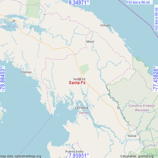
Santa Fé GPS coordinates[2]
8° 39' 18.9" North, 78° 9' 41.04" West
| Map corner | latitude | longitude |
|---|---|---|
| Upper-left | 9.34971°, | -78.86453° |
| Center: | 8.65525°, | -78.1614° |
| Lower-right: | 7.95951°, | -77.45828° |
| Map W x H: | 154.6×154.6 km | = 96.1×96.1mi |
| max Lat: | 9.60898° ⇑32.1% North |
| Santa Fé: | 8.65525° |
| min Lat: | ⇓67.9% South 7.26534° |
| min Long | Santa Fé | max Long |
| -82.91275° | -78.1614° | -77.38965° |
| W 95.8%⇐ | ⇒4.2% E |
Elevation
Elevation of Santa Fé is 16 m = 52 ft, and this is 156.1 m = 512 ft below average elevation for this country.
| Max E: |
2103 m = 6900 ft | 86.3% |
| Avg. | 172.1 m = 565 ft | |
| Santa Fé | 16 m = 52 ft | |
Min E: |
-1 m = -3 ft | 13.7% |
See also: Panama elevation on elevation.city.
Geographical zone
Santa Fé is located in North Torrid zone (between Equator and Tropic of Cancer). Distance of Equator is 962.4 km =598 mi to South.| Distance of | km | miles | from Santa Fé |
|---|---|---|---|
| North Pole | 9044.7 | 5620.1 | to North |
| Arctic Circle | 6438.8 | 4000.9 | to North |
| Tropic Cancer | 1643.5 | 1021.2 | to North |
| Equator | 962.4 | 598 | to South |


Nearby cities:
15 places around Santa Fé: (largest is in red/bold)
• Agua Fría Número Uno
22.9 km =14.2 mi,  350°
350°
• Barriales
26.2 km =16.3 mi,  252°
252°
• Cañazas
28 km =17.4 mi, 345°
• Cucunatí
13.8 km =8.6 mi,  229°
229°
• La Palma
27.8 km =17.3 mi,  175°
175°
• Metetí
26.5 km =16.5 mi,  130°
130°
• Mortí
29.2 km =18.1 mi,  44°
44°
• Mortí
34.7 km =21.6 mi,  50°
50°
• Platanilla
31.1 km =19.3 mi,  308°
308°
• Quebrada Honda
5.8 km =3.6 mi,  112°
112°
• Setegantí
40.7 km =25.3 mi,  170°
170°
• Tortí
39.9 km =24.8 mi,  317°
317°
• Ualá
38.4 km =23.9 mi,  16°
16°
• Villa Darién
20.8 km =12.9 mi, 125°
• Zapallal
3.5 km =2.2 mi,  100°
100°
Sources, notices
• [Note1] Compared only with cities in Panama existing in our database
• [Src1] Map data: © OpenStreetMap contributors (CC-BY-SA)
• [Src2] Other city data from geonames.org with taken over terms of usage.
• [Src3] Geographical zone / Annual Mean Temperature by Robert A. Rohde @ Wikipedia
