Cabuya geodata
Cabuya (Herrera) is a seat of a third-order administrative division; located in Panama in America/Panama (GMT-5) time zone. In our database, there are 694 cities with bigger population. Compared to other cities in Panama, 82.1% of cities are located further ↑North; 55.9% of cities are located further →East and 57.4% of cities have lower elevation than Cabuya. Note1


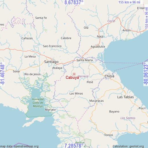
Cabuya GPS coordinates[2]
7° 58' 57.612" North, 80° 45' 51.66" West
| Map corner | latitude | longitude |
|---|---|---|
| Upper-left | 8.67837°, | -81.46748° |
| Center: | 7.98267°, | -80.76435° |
| Lower-right: | 7.28578°, | -80.06123° |
| Map W x H: | 154.8×154.8 km | = 96.2×96.2mi |
| max Lat: | 9.60898° ⇑82.1% North |
| Cabuya: | 7.98267° |
| min Lat: | ⇓17.9% South 7.26534° |
| min Long | Cabuya | max Long |
| -82.91275° | -80.76435° | -77.38965° |
| W 44.1%⇐ | ⇒55.9% E |
Elevation
Elevation of Cabuya is 94 m = 308 ft, and this is 78.1 m = 256 ft below average elevation for this country.
| Max E: |
2103 m = 6900 ft | 42.6% |
| Avg. | 172.1 m = 565 ft | |
| Cabuya | 94 m = 308 ft | |
Min E: |
-1 m = -3 ft | 57.4% |
See also: Panama elevation on elevation.city.
Geographical zone
Cabuya is located in North Torrid zone (between Equator and Tropic of Cancer). Distance of Equator is 887.6 km =551.5 mi to South.| Distance of | km | miles | from Cabuya |
|---|---|---|---|
| North Pole | 9119.5 | 5666.6 | to North |
| Arctic Circle | 6513.6 | 4047.4 | to North |
| Tropic Cancer | 1718.3 | 1067.7 | to North |
| Equator | 887.6 | 551.5 | to South |


Nearby cities:
15 places around Cabuya: (largest is in red/bold)
• Cabuya
15.5 km =9.6 mi,  69°
69°
• Chupampa
10.5 km =6.5 mi,  352°
352°
• El Espino de Santa Rosa
13.9 km =8.6 mi,  331°
331°
• El Limón
8.4 km =5.2 mi, 353°
• El Pedregoso
14.8 km =9.2 mi,  110°
110°
• La Carrillo
13.2 km =8.2 mi,  263°
263°
• La Montañuela
11.9 km =7.4 mi,  293°
293°
• La Trinidad
10.1 km =6.3 mi,  138°
138°
• Las Guabas
9.4 km =5.8 mi,  210°
210°
• Llano Grande
5.9 km =3.7 mi,  99°
99°
• Llano de La Cruz
13.9 km =8.6 mi, 104°
• Los Boquerones
14.6 km =9.1 mi,  317°
317°
• Ocú
5 km =3.1 mi,  199°
199°
• Peñas Chatas
5.6 km =3.5 mi,  309°
309°
• San José
9.8 km =6.1 mi,  249°
249°
Sources, notices
• [Note1] Compared only with cities in Panama existing in our database
• [Src1] Map data: © OpenStreetMap contributors (CC-BY-SA)
• [Src2] Other city data from geonames.org with taken over terms of usage.
• [Src3] Geographical zone / Annual Mean Temperature by Robert A. Rohde @ Wikipedia
