Pebas geodata
Pebas (Loreto) is a seat of a third-order administrative division; located in Peru in America/Lima (GMT-5) time zone. In our database, there are 305 cities with bigger population. Compared to other cities in Peru, 99.8% of cities are located further ↓South; 81.8% of cities are located further ←West and 91.3% of cities have higher elevation than Pebas. Note1


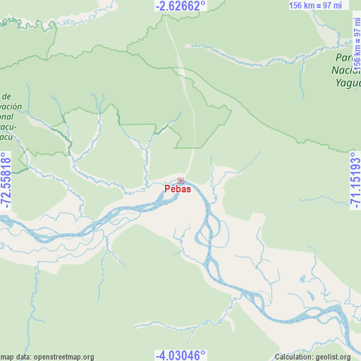
Pebas GPS coordinates[2]
3° 19' 43.644" South, 71° 51' 18.18" West
| Map corner | latitude | longitude |
|---|---|---|
| Upper-left | -2.62662°, | -72.55818° |
| Center: | -3.32879°, | -71.85505° |
| Lower-right: | -4.03046°, | -71.15193° |
| Map W x H: | 156.1×156.1 km | = 97×97mi |
| max Lat: | -0.96667° ⇑0.2% North |
| Pebas: | -3.32879° |
| min Lat: | ⇓99.8% South -18.01465° |
| min Long | Pebas | max Long |
| -81.30472° | -71.85505° | -69.04167° |
| W 81.8%⇐ | ⇒18.2% E |
Elevation
Elevation of Pebas is 73 m = 240 ft, and this is 2245.7 m = 7368 ft below average elevation for this country.
| Max E: |
5022 m = 16476 ft | 91.3% |
| Avg. | 2318.7 m = 7607 ft | |
| Pebas | 73 m = 240 ft | |
Min E: |
1 m = 3 ft | 8.7% |
See also: Peru elevation on elevation.city.
Geographical zone
Pebas is located in South Torrid zone (between Equator and Tropic of Capricorn). Distance of Equator is 370.1 km =230 mi to North.| Distance of | km | miles | from Pebas |
|---|---|---|---|
| Equator | 370.1 | 230 | to North |
| Tropic Capricorn | 2235.8 | 1389.3 | to South |
| Antarctic Circle | 7031 | 4368.9 | to South |
| South Pole | 9636.9 | 5988.1 | to South |


Nearby cities:
15 places around Pebas: (largest is in red/bold)
• Bretaña
344.8 km =214.2 mi,  231°
231°
• Caballococha
161.8 km =100.5 mi,  113°
113°
• Concordia
352.8 km =219.2 mi,  247°
247°
• Genaro Herrera
266.9 km =165.8 mi, 228°
• Iberia
363.7 km =226 mi,  224°
224°
• Indiana
134.1 km =83.3 mi,  261°
261°
• Iquitos
162.1 km =100.7 mi, 253°
• Nauta
230.8 km =143.4 mi, 234°
• Parinari
317.4 km =197.2 mi,  244°
244°
• Ramón Castilla
234.7 km =145.8 mi,  116°
116°
• Requena
293.3 km =182.2 mi, 228°
• San Antonio del Estrecho
133.1 km =82.7 mi,  317°
317°
• San Juan
199.8 km =124.1 mi, 251°
• Saquena
236.8 km =147.1 mi, 231°
• Trompeteros
359.6 km =223.4 mi, 261°
Sources, notices
• [Note1] Compared only with cities in Peru existing in our database
• [Src1] Map data: © OpenStreetMap contributors (CC-BY-SA)
• [Src2] Other city data from geonames.org with taken over terms of usage.
• [Src3] Geographical zone / Annual Mean Temperature by Robert A. Rohde @ Wikipedia
