Chaglla geodata
Chaglla (Huanuco) is a seat of a third-order administrative division; located in Peru in America/Lima (GMT-5) time zone. In our database, there are 305 cities with bigger population. Compared to other cities in Peru, 62.2% of cities are located further ↓South; 52.4% of cities are located further →East and 54.6% of cities have lower elevation than Chaglla. Note1


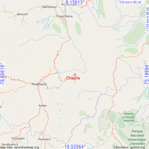
Chaglla GPS coordinates[2]
9° 50' 36.996" South, 75° 54' 11.016" West
| Map corner | latitude | longitude |
|---|---|---|
| Upper-left | -9.15013°, | -76.60619° |
| Center: | -9.84361°, | -75.90306° |
| Lower-right: | -10.53564°, | -75.19994° |
| Map W x H: | 154.1×154.1 km | = 95.8×95.8mi |
| max Lat: | -0.96667° ⇑37.8% North |
| Chaglla: | -9.84361° |
| min Lat: | ⇓62.2% South -18.01465° |
| min Long | Chaglla | max Long |
| -81.30472° | -75.90306° | -69.04167° |
| W 47.6%⇐ | ⇒52.4% E |
Elevation
Elevation of Chaglla is 3011 m = 9879 ft, and this is 692.3 m = 2271 ft above average elevation for this country.
| Max E: |
5022 m = 16476 ft | 45.4% |
| Chaglla | 3011 m 9879 ft | |
| Avg. | 2318.7 m = 7607 ft | |
Min E: |
1 m = 3 ft | 54.6% |
See also: Peru elevation on elevation.city.
Geographical zone
Chaglla is located in South Torrid zone (between Equator and Tropic of Capricorn). Distance of Equator is 1094.5 km =680.1 mi to North.| Distance of | km | miles | from Chaglla |
|---|---|---|---|
| Equator | 1094.5 | 680.1 | to North |
| Tropic Capricorn | 1511.4 | 939.1 | to South |
| Antarctic Circle | 6306.7 | 3918.8 | to South |
| South Pole | 8912.6 | 5538 | to South |


Nearby cities:
15 places around Chaglla: (largest is in red/bold)
• Acomayo
19.1 km =11.9 mi,  284°
284°
• Ambo
45.9 km =28.5 mi,  225°
225°
• Cayhuayna
39.9 km =24.8 mi,  251°
251°
• Churubamba
25.3 km =15.7 mi,  274°
274°
• Conchamarca
40.4 km =25.1 mi,  237°
237°
• Huacar
50.8 km =31.6 mi, 226°
• Huancapallac
56.3 km =35 mi,  264°
264°
• Huánuco
38.4 km =23.9 mi, 255°
• Las Palmas
52.3 km =32.5 mi,  347°
347°
• Panao
11.6 km =7.2 mi, 238°
• Paucarbamba
36.8 km =22.9 mi, 252°
• Pozuzo
47.5 km =29.5 mi,  121°
121°
• San Rafael
63 km =39.1 mi,  209°
209°
• Tingo María
61.8 km =38.4 mi, 350°
• Tomay Kichwa
42.6 km =26.5 mi, 232°
Sources, notices
• [Note1] Compared only with cities in Peru existing in our database
• [Src1] Map data: © OpenStreetMap contributors (CC-BY-SA)
• [Src2] Other city data from geonames.org with taken over terms of usage.
• [Src3] Geographical zone / Annual Mean Temperature by Robert A. Rohde @ Wikipedia
