Vanimo geodata
Vanimo (Sandaun) is a seat of a first-order administrative division; located in Papua New Guinea in Pacific/Port_Moresby (GMT+10) time zone. With population of 11,204 people, there are 16 cities with bigger population in this country. Compared to other cities in Papua New Guinea, 95.5% of cities are located further ↓South; 97.7% of cities are located further →East and 79.5% of cities have higher elevation than Vanimo. Note1


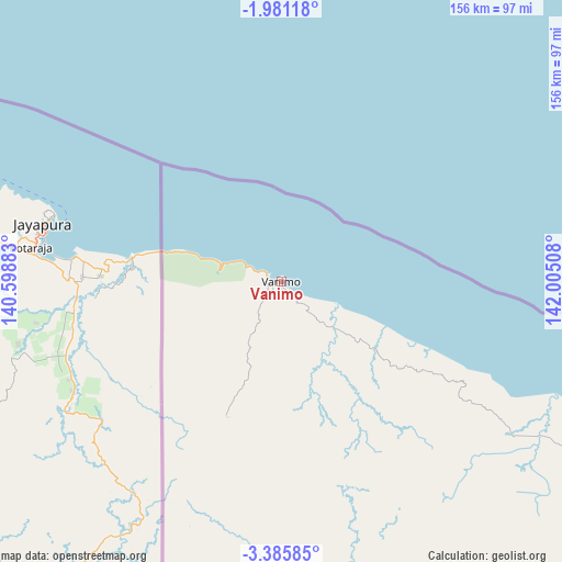
Vanimo GPS coordinates[2]
2° 41' 1.392" South, 141° 18' 7.02" East
| Map corner | latitude | longitude |
|---|---|---|
| Upper-left | -1.98118°, | 140.59883° |
| Center: | -2.68372°, | 141.30195° |
| Lower-right: | -3.38585°, | 142.00508° |
| Map W x H: | 156.2×156.2 km | = 97.1×97.1mi |
| max Lat: | -2.0341° ⇑4.5% North |
| Vanimo: | -2.68372° |
| min Lat: | ⇓95.5% South -10.61038° |
| min Long | Vanimo | max Long |
| 141.29061° | 141.30195° | 155.69147° |
| W 2.3%⇐ | ⇒97.7% E |
Elevation
Elevation of Vanimo is 5 m = 16 ft, and this is 576 m = 1890 ft below average elevation for this country.
| Max E: |
2248 m = 7375 ft | 79.5% |
| Avg. | 581 m = 1906 ft | |
| Vanimo | 5 m = 16 ft | |
Min E: |
0 m = 0 ft | 20.5% |
See also: Papua New Guinea elevation on elevation.city.
Geographical zone
Vanimo is located in South Torrid zone (between Equator and Tropic of Capricorn). Distance of Equator is 298.4 km =185.4 mi to North.| Distance of | km | miles | from Vanimo |
|---|---|---|---|
| Equator | 298.4 | 185.4 | to North |
| Tropic Capricorn | 2307.5 | 1433.8 | to South |
| Antarctic Circle | 7102.8 | 4413.5 | to South |
| South Pole | 9708.7 | 6032.7 | to South |


Nearby cities:
9 places around Vanimo: (largest is in red/bold)
• Aitape
126.7 km =78.7 mi,  113°
113°
• Ambunti
239.6 km =148.9 mi,  135°
135°
• Angoram
343 km =213.1 mi,  116°
116°
• Kiunga
382.3 km =237.6 mi,  180°
180°
• Laiagam
403.5 km =250.7 mi, 136°
• Porgera
370.7 km =230.3 mi,  146°
146°
• Tari
396 km =246.1 mi, 152°
• Wabag
411.6 km =255.8 mi, 139°
• Wewak
276.1 km =171.6 mi, 110°
Sources, notices
• [Note1] Compared only with cities in Papua New Guinea existing in our database
• [Src1] Map data: © OpenStreetMap contributors (CC-BY-SA)
• [Src2] Other city data from geonames.org with taken over terms of usage.
• [Src3] Geographical zone / Annual Mean Temperature by Robert A. Rohde @ Wikipedia
