Tari geodata
Tari (Hela) is a seat of a first-order administrative division; located in Papua New Guinea in Pacific/Port_Moresby (GMT+10) time zone. With population of 8,186 people, there are 20 cities with bigger population in this country. Compared to other cities in Papua New Guinea, 63.6% of cities are located further ↓South; 88.6% of cities are located further →East and 86.4% of cities have lower elevation than Tari. Note1


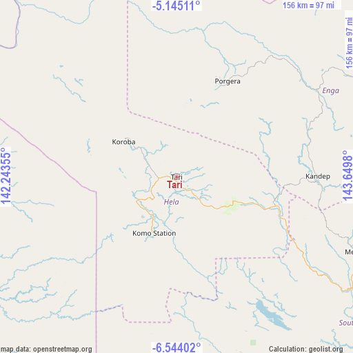
Tari GPS coordinates[2]
5° 50' 42" South, 142° 56' 48.012" East
| Map corner | latitude | longitude |
|---|---|---|
| Upper-left | -5.14511°, | 142.24355° |
| Center: | -5.845°, | 142.94667° |
| Lower-right: | -6.54402°, | 143.6498° |
| Map W x H: | 155.5×155.5 km | = 96.6×96.6mi |
| max Lat: | -2.0341° ⇑36.4% North |
| Tari: | -5.845° |
| min Lat: | ⇓63.6% South -10.61038° |
| min Long | Tari | max Long |
| 141.29061° | 142.94667° | 155.69147° |
| W 11.4%⇐ | ⇒88.6% E |
Elevation
Elevation of Tari is 1676 m = 5499 ft, and this is 1095 m = 3593 ft above average elevation for this country.
| Max E: |
2248 m = 7375 ft | 13.6% |
| Tari | 1676 m 5499 ft | |
| Avg. | 581 m = 1906 ft | |
Min E: |
0 m = 0 ft | 86.4% |
See also: Papua New Guinea elevation on elevation.city.
Geographical zone
Tari is located in South Torrid zone (between Equator and Tropic of Capricorn). Distance of Equator is 649.9 km =403.8 mi to North.| Distance of | km | miles | from Tari |
|---|---|---|---|
| Equator | 649.9 | 403.8 | to North |
| Tropic Capricorn | 1956 | 1215.4 | to South |
| Antarctic Circle | 6751.3 | 4195.1 | to South |
| South Pole | 9357.2 | 5814.3 | to South |


Nearby cities:
15 places around Tari: (largest is in red/bold)
• Ambunti
181.6 km =112.8 mi,  355°
355°
• Angoram
233.8 km =145.3 mi,  32°
32°
• Goroka
271.1 km =168.5 mi,  95°
95°
• Ialibu
125.5 km =78 mi,  112°
112°
• Kiunga
185.7 km =115.4 mi,  260°
260°
• Kundiawa
224.5 km =139.5 mi,  94°
94°
• Kurumul
186.3 km =115.8 mi, 90°
• Laiagam
109.5 km =68 mi,  58°
58°
• Mendi
85.4 km =53.1 mi, 113°
• Minj
193.1 km =120 mi, 92°
• Mount Hagen
142 km =88.2 mi, 90°
• Porgera
48 km =29.8 mi, 27°
• Rauna
148.9 km =92.5 mi, 85°
• Wabag
94.3 km =58.6 mi,  65°
65°
• Wewak
266.3 km =165.5 mi,  16°
16°
Sources, notices
• [Note1] Compared only with cities in Papua New Guinea existing in our database
• [Src1] Map data: © OpenStreetMap contributors (CC-BY-SA)
• [Src2] Other city data from geonames.org with taken over terms of usage.
• [Src3] Geographical zone / Annual Mean Temperature by Robert A. Rohde @ Wikipedia
