Ambunti geodata
Ambunti (East Sepik) is a populated place; located in Papua New Guinea in Pacific/Port_Moresby (GMT+10) time zone. With population of 2,073 people, there are 31 cities with bigger population in this country. Compared to other cities in Papua New Guinea, 84.1% of cities are located further ↓South; 90.9% of cities are located further →East and 54.5% of cities have higher elevation than Ambunti. Note1


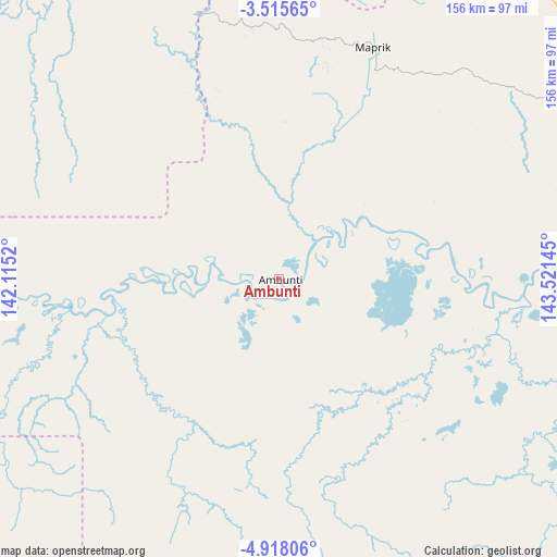
Ambunti GPS coordinates[2]
4° 13' 1.812" South, 142° 49' 5.952" East
| Map corner | latitude | longitude |
|---|---|---|
| Upper-left | -3.51565°, | 142.1152° |
| Center: | -4.21717°, | 142.81832° |
| Lower-right: | -4.91806°, | 143.52145° |
| Map W x H: | 155.9×155.9 km | = 96.9×96.9mi |
| max Lat: | -2.0341° ⇑15.9% North |
| Ambunti: | -4.21717° |
| min Lat: | ⇓84.1% South -10.61038° |
| min Long | Ambunti | max Long |
| 141.29061° | 142.81832° | 155.69147° |
| W 9.1%⇐ | ⇒90.9% E |
Elevation
Elevation of Ambunti is 29 m = 95 ft, and this is 552 m = 1811 ft below average elevation for this country.
| Max E: |
2248 m = 7375 ft | 54.5% |
| Avg. | 581 m = 1906 ft | |
| Ambunti | 29 m = 95 ft | |
Min E: |
0 m = 0 ft | 45.5% |
See also: Papua New Guinea elevation on elevation.city.
Geographical zone
Ambunti is located in South Torrid zone (between Equator and Tropic of Capricorn). Distance of Equator is 468.9 km =291.4 mi to North.| Distance of | km | miles | from Ambunti |
|---|---|---|---|
| Equator | 468.9 | 291.4 | to North |
| Tropic Capricorn | 2137 | 1327.9 | to South |
| Antarctic Circle | 6932.3 | 4307.5 | to South |
| South Pole | 9538.2 | 5926.8 | to South |


Nearby cities:
15 places around Ambunti: (largest is in red/bold)
• Aitape
130.9 km =81.3 mi,  336°
336°
• Angoram
139.4 km =86.6 mi,  82°
82°
• Ialibu
263.9 km =164 mi,  150°
150°
• Kiunga
271.1 km =168.5 mi,  218°
218°
• Kurumul
271.1 km =168.5 mi,  132°
132°
• Laiagam
164.1 km =102 mi,  138°
138°
• Mendi
233.8 km =145.3 mi,  156°
156°
• Minj
279.9 km =173.9 mi, 132°
• Mount Hagen
240.3 km =149.3 mi, 139°
• Porgera
143.3 km =89 mi,  165°
165°
• Rauna
234.6 km =145.8 mi, 136°
• Tari
181.6 km =112.8 mi,  175°
175°
• Vanimo
239.6 km =148.9 mi,  315°
315°
• Wabag
173.4 km =107.7 mi, 144°
• Wewak
116.9 km =72.6 mi,  50°
50°
Sources, notices
• [Note1] Compared only with cities in Papua New Guinea existing in our database
• [Src1] Map data: © OpenStreetMap contributors (CC-BY-SA)
• [Src2] Other city data from geonames.org with taken over terms of usage.
• [Src3] Geographical zone / Annual Mean Temperature by Robert A. Rohde @ Wikipedia
