Laiagam geodata
Laiagam (Enga) is a populated place; located in Papua New Guinea in Pacific/Port_Moresby (GMT+10) time zone. With population of 921 people, there are 37 cities with bigger population in this country. Compared to other cities in Papua New Guinea, 77.3% of cities are located further ↓South; 75% of cities are located further →East and 93.2% of cities have lower elevation than Laiagam. Note1


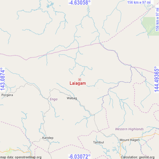
Laiagam GPS coordinates[2]
5° 19' 51.78" South, 143° 47' 25.872" East
| Map corner | latitude | longitude |
|---|---|---|
| Upper-left | -4.63058°, | 143.0874° |
| Center: | -5.33105°, | 143.79052° |
| Lower-right: | -6.03072°, | 144.49365° |
| Map W x H: | 155.7×155.7 km | = 96.7×96.7mi |
| max Lat: | -2.0341° ⇑22.7% North |
| Laiagam: | -5.33105° |
| min Lat: | ⇓77.3% South -10.61038° |
| min Long | Laiagam | max Long |
| 141.29061° | 143.79052° | 155.69147° |
| W 25%⇐ | ⇒75% E |
Elevation
Elevation of Laiagam is 1894 m = 6214 ft, and this is 1313 m = 4308 ft above average elevation for this country.
| Max E: |
2248 m = 7375 ft | 6.8% |
| Laiagam | 1894 m 6214 ft | |
| Avg. | 581 m = 1906 ft | |
Min E: |
0 m = 0 ft | 93.2% |
See also: Papua New Guinea elevation on elevation.city.
Geographical zone
Laiagam is located in South Torrid zone (between Equator and Tropic of Capricorn). Distance of Equator is 592.8 km =368.3 mi to North.| Distance of | km | miles | from Laiagam |
|---|---|---|---|
| Equator | 592.8 | 368.3 | to North |
| Tropic Capricorn | 2013.2 | 1250.9 | to South |
| Antarctic Circle | 6808.4 | 4230.5 | to South |
| South Pole | 9414.3 | 5849.8 | to South |


Nearby cities:
15 places around Laiagam: (largest is in red/bold)
• Ambunti
164.1 km =102 mi,  318°
318°
• Angoram
144.3 km =89.7 mi,  12°
12°
• Goroka
195.5 km =121.5 mi,  115°
115°
• Ialibu
108.1 km =67.2 mi,  168°
168°
• Kundiawa
151.2 km =94 mi, 120°
• Kurumul
109.8 km =68.2 mi, 122°
• Madang
221.4 km =137.6 mi,  86°
86°
• Mendi
92 km =57.2 mi,  189°
189°
• Minj
118.5 km =73.6 mi, 122°
• Mount Hagen
76.1 km =47.3 mi,  140°
140°
• Porgera
72.6 km =45.1 mi,  258°
258°
• Rauna
71.1 km =44.2 mi,  129°
129°
• Tari
109.5 km =68 mi,  238°
238°
• Wabag
19.4 km =12.1 mi,  203°
203°
• Wewak
198.8 km =123.5 mi,  354°
354°
Sources, notices
• [Note1] Compared only with cities in Papua New Guinea existing in our database
• [Src1] Map data: © OpenStreetMap contributors (CC-BY-SA)
• [Src2] Other city data from geonames.org with taken over terms of usage.
• [Src3] Geographical zone / Annual Mean Temperature by Robert A. Rohde @ Wikipedia
