Wau geodata
Wau (Morobe) is a populated place; located in Papua New Guinea in Pacific/Port_Moresby (GMT+10) time zone. With population of 14,629 people, there are 13 cities with bigger population in this country. Compared to other cities in Papua New Guinea, 77.3% of cities are located further ↑North; 56.8% of cities are located further ←West and 70.5% of cities have lower elevation than Wau. Note1


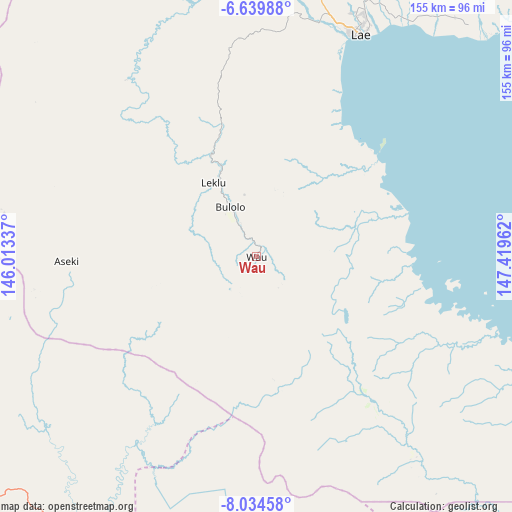
Wau GPS coordinates[2]
7° 20' 16.008" South, 146° 42' 59.364" East
| Map corner | latitude | longitude |
|---|---|---|
| Upper-left | -6.63988°, | 146.01337° |
| Center: | -7.33778°, | 146.71649° |
| Lower-right: | -8.03458°, | 147.41962° |
| Map W x H: | 155.1×155.1 km | = 96.4×96.4mi |
| max Lat: | -2.0341° ⇑77.3% North |
| Wau: | -7.33778° |
| min Lat: | ⇓22.7% South -10.61038° |
| min Long | Wau | max Long |
| 141.29061° | 146.71649° | 155.69147° |
| W 56.8%⇐ | ⇒43.2% E |
Elevation
Elevation of Wau is 1082 m = 3550 ft, and this is 501 m = 1644 ft above average elevation for this country.
| Max E: |
2248 m = 7375 ft | 29.5% |
| Wau | 1082 m 3550 ft | |
| Avg. | 581 m = 1906 ft | |
Min E: |
0 m = 0 ft | 70.5% |
See also: Papua New Guinea elevation on elevation.city.
Geographical zone
Wau is located in South Torrid zone (between Equator and Tropic of Capricorn). Distance of Equator is 815.9 km =507 mi to North.| Distance of | km | miles | from Wau |
|---|---|---|---|
| Equator | 815.9 | 507 | to North |
| Tropic Capricorn | 1790 | 1112.3 | to South |
| Antarctic Circle | 6585.3 | 4091.9 | to South |
| South Pole | 9191.2 | 5711.1 | to South |


Nearby cities:
15 places around Wau: (largest is in red/bold)
• Bulolo
17.1 km =10.6 mi,  330°
330°
• Finschhafen
151.9 km =94.4 mi,  55°
55°
• Goroka
202.4 km =125.8 mi,  313°
313°
• Ihu
158.4 km =98.4 mi,  246°
246°
• Kainantu
149.8 km =93.1 mi,  321°
321°
• Kerema
124.9 km =77.6 mi,  236°
236°
• Kokoda
204.8 km =127.3 mi,  146°
146°
• Kundiawa
242.3 km =150.6 mi, 307°
• Kurumul
283.3 km =176 mi, 305°
• Kwikila
294.7 km =183.1 mi,  159°
159°
• Lae
75 km =46.6 mi,  24°
24°
• Madang
256.8 km =159.6 mi,  336°
336°
• Minj
274.4 km =170.5 mi, 305°
• Popondetta
230.3 km =143.1 mi,  133°
133°
• Port Moresby
242.6 km =150.7 mi,  168°
168°
Sources, notices
• [Note1] Compared only with cities in Papua New Guinea existing in our database
• [Src1] Map data: © OpenStreetMap contributors (CC-BY-SA)
• [Src2] Other city data from geonames.org with taken over terms of usage.
• [Src3] Geographical zone / Annual Mean Temperature by Robert A. Rohde @ Wikipedia
