Finschhafen geodata
Finschhafen (Morobe) is a populated place; located in Papua New Guinea in Pacific/Port_Moresby (GMT+10) time zone. With population of 1,054 people, there are 35 cities with bigger population in this country. Compared to other cities in Papua New Guinea, 68.2% of cities are located further ↑North; 70.5% of cities are located further ←West and 63.6% of cities have higher elevation than Finschhafen. Note1


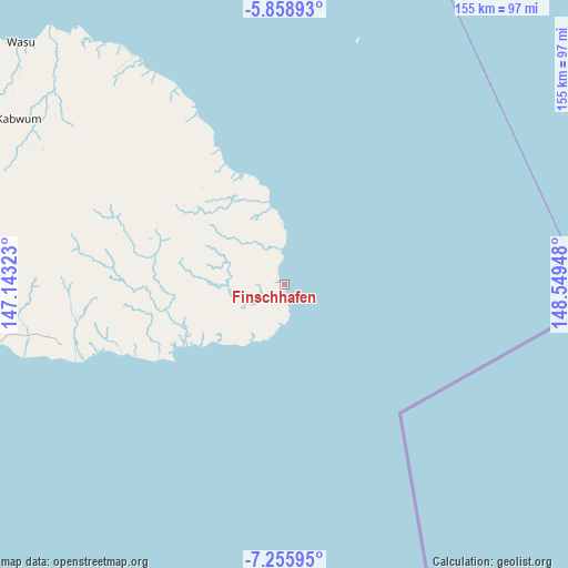
Finschhafen GPS coordinates[2]
6° 33' 28.548" South, 147° 50' 46.86" East
| Map corner | latitude | longitude |
|---|---|---|
| Upper-left | -5.85893°, | 147.14323° |
| Center: | -6.55793°, | 147.84635° |
| Lower-right: | -7.25595°, | 148.54948° |
| Map W x H: | 155.3×155.3 km | = 96.5×96.5mi |
| max Lat: | -2.0341° ⇑68.2% North |
| Finschhafen: | -6.55793° |
| min Lat: | ⇓31.8% South -10.61038° |
| min Long | Finschhafen | max Long |
| 141.29061° | 147.84635° | 155.69147° |
| W 70.5%⇐ | ⇒29.5% E |
Elevation
Elevation of Finschhafen is 16 m = 52 ft, and this is 565 m = 1854 ft below average elevation for this country.
| Max E: |
2248 m = 7375 ft | 63.6% |
| Avg. | 581 m = 1906 ft | |
| Finschhafen | 16 m = 52 ft | |
Min E: |
0 m = 0 ft | 36.4% |
See also: Papua New Guinea elevation on elevation.city.
Geographical zone
Finschhafen is located in South Torrid zone (between Equator and Tropic of Capricorn). Distance of Equator is 729.2 km =453.1 mi to North.| Distance of | km | miles | from Finschhafen |
|---|---|---|---|
| Equator | 729.2 | 453.1 | to North |
| Tropic Capricorn | 1876.7 | 1166.1 | to South |
| Antarctic Circle | 6672 | 4145.8 | to South |
| South Pole | 9277.9 | 5765 | to South |


Nearby cities:
15 places around Finschhafen: (largest is in red/bold)
• Bulolo
151.3 km =94 mi,  241°
241°
• Goroka
276.9 km =172.1 mi,  280°
280°
• Ihu
308.7 km =191.8 mi, 241°
• Kainantu
220.9 km =137.3 mi, 277°
• Kandrian
192 km =119.3 mi,  78°
78°
• Kerema
276.8 km =172 mi, 235°
• Kimbe
277 km =172.1 mi,  66°
66°
• Kokoda
258.2 km =160.4 mi,  182°
182°
• Kundiawa
323.6 km =201.1 mi, 280°
• Lae
95.7 km =59.5 mi,  258°
258°
• Madang
272 km =169 mi,  303°
303°
• Minj
356.1 km =221.3 mi, 281°
• Popondetta
249.1 km =154.8 mi,  170°
170°
• Port Moresby
333.5 km =207.2 mi,  193°
193°
• Wau
151.9 km =94.4 mi, 235°
Sources, notices
• [Note1] Compared only with cities in Papua New Guinea existing in our database
• [Src1] Map data: © OpenStreetMap contributors (CC-BY-SA)
• [Src2] Other city data from geonames.org with taken over terms of usage.
• [Src3] Geographical zone / Annual Mean Temperature by Robert A. Rohde @ Wikipedia
