Popondetta geodata
Popondetta (Northern Province) is a seat of a first-order administrative division; located in Papua New Guinea in Pacific/Port_Moresby (GMT+10) time zone. With population of 28,198 people, there are 4 cities with bigger population in this country. Compared to other cities in Papua New Guinea, 86.4% of cities are located further ↑North; 72.7% of cities are located further ←West and 61.4% of cities have lower elevation than Popondetta. Note1


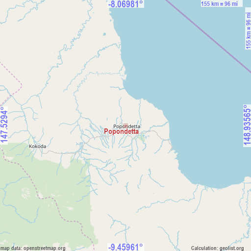
Popondetta GPS coordinates[2]
8° 45' 55.296" South, 148° 13' 57.072" East
| Map corner | latitude | longitude |
|---|---|---|
| Upper-left | -8.06981°, | 147.5294° |
| Center: | -8.76536°, | 148.23252° |
| Lower-right: | -9.45961°, | 148.93565° |
| Map W x H: | 154.5×154.5 km | = 96×96mi |
| max Lat: | -2.0341° ⇑86.4% North |
| Popondetta: | -8.76536° |
| min Lat: | ⇓13.6% South -10.61038° |
| min Long | Popondetta | max Long |
| 141.29061° | 148.23252° | 155.69147° |
| W 72.7%⇐ | ⇒27.3% E |
Elevation
Elevation of Popondetta is 106 m = 348 ft, and this is 475 m = 1558 ft below average elevation for this country.
| Max E: |
2248 m = 7375 ft | 38.6% |
| Avg. | 581 m = 1906 ft | |
| Popondetta | 106 m = 348 ft | |
Min E: |
0 m = 0 ft | 61.4% |
See also: Papua New Guinea elevation on elevation.city.
Geographical zone
Popondetta is located in South Torrid zone (between Equator and Tropic of Capricorn). Distance of Equator is 974.6 km =605.6 mi to North.| Distance of | km | miles | from Popondetta |
|---|---|---|---|
| Equator | 974.6 | 605.6 | to North |
| Tropic Capricorn | 1631.3 | 1013.6 | to South |
| Antarctic Circle | 6426.6 | 3993.3 | to South |
| South Pole | 9032.4 | 5612.5 | to South |


Nearby cities:
15 places around Popondetta: (largest is in red/bold)
• Alotau
298.7 km =185.6 mi,  125°
125°
• Bulolo
246.8 km =153.4 mi,  314°
314°
• Finschhafen
249.1 km =154.8 mi,  350°
350°
• Goroka
432.7 km =268.9 mi, 313°
• Ihu
326.9 km =203.1 mi,  287°
287°
• Kainantu
379.3 km =235.7 mi,  316°
316°
• Kandrian
319.3 km =198.4 mi,  26°
26°
• Kerema
285 km =177.1 mi, 288°
• Kimbe
414.6 km =257.6 mi, 30°
• Kokoda
55.9 km =34.7 mi,  257°
257°
• Kwikila
132.9 km =82.6 mi,  208°
208°
• Lae
264.8 km =164.5 mi,  329°
329°
• Port Moresby
142.7 km =88.7 mi,  236°
236°
• Samarai
336.1 km =208.8 mi, 127°
• Wau
230.3 km =143.1 mi, 313°
Sources, notices
• [Note1] Compared only with cities in Papua New Guinea existing in our database
• [Src1] Map data: © OpenStreetMap contributors (CC-BY-SA)
• [Src2] Other city data from geonames.org with taken over terms of usage.
• [Src3] Geographical zone / Annual Mean Temperature by Robert A. Rohde @ Wikipedia
