Bulolo geodata
Bulolo (Morobe) is a populated place; located in Papua New Guinea in Pacific/Port_Moresby (GMT+10) time zone. With population of 16,042 people, there are 11 cities with bigger population in this country. Compared to other cities in Papua New Guinea, 75% of cities are located further ↑North; 54.5% of cities are located further ←West and 68.2% of cities have lower elevation than Bulolo. Note1


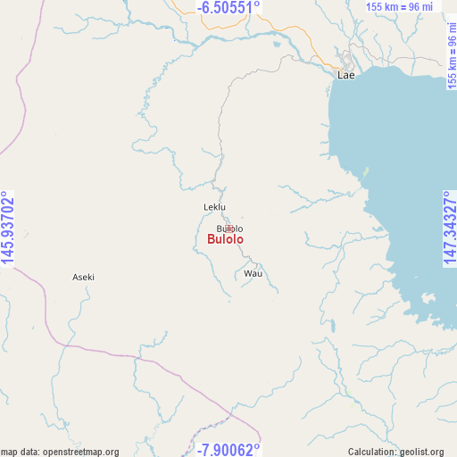
Bulolo GPS coordinates[2]
7° 12' 12.96" South, 146° 38' 24.504" East
| Map corner | latitude | longitude |
|---|---|---|
| Upper-left | -6.50551°, | 145.93702° |
| Center: | -7.2036°, | 146.64014° |
| Lower-right: | -7.90062°, | 147.34327° |
| Map W x H: | 155.1×155.1 km | = 96.4×96.4mi |
| max Lat: | -2.0341° ⇑75% North |
| Bulolo: | -7.2036° |
| min Lat: | ⇓25% South -10.61038° |
| min Long | Bulolo | max Long |
| 141.29061° | 146.64014° | 155.69147° |
| W 54.5%⇐ | ⇒45.5% E |
Elevation
Elevation of Bulolo is 677 m = 2221 ft, and this is 96 m = 315 ft above average elevation for this country.
| Max E: |
2248 m = 7375 ft | 31.8% |
| Bulolo | 677 m 2221 ft | |
| Avg. | 581 m = 1906 ft | |
Min E: |
0 m = 0 ft | 68.2% |
See also: Papua New Guinea elevation on elevation.city.
Geographical zone
Bulolo is located in South Torrid zone (between Equator and Tropic of Capricorn). Distance of Equator is 801 km =497.7 mi to North.| Distance of | km | miles | from Bulolo |
|---|---|---|---|
| Equator | 801 | 497.7 | to North |
| Tropic Capricorn | 1805 | 1121.6 | to South |
| Antarctic Circle | 6600.2 | 4101.2 | to South |
| South Pole | 9206.1 | 5720.4 | to South |


Nearby cities:
15 places around Bulolo: (largest is in red/bold)
• Finschhafen
151.3 km =94 mi,  61°
61°
• Goroka
186.1 km =115.6 mi,  311°
311°
• Ihu
157.4 km =97.8 mi,  240°
240°
• Kainantu
132.9 km =82.6 mi,  319°
319°
• Kerema
127.3 km =79.1 mi,  228°
228°
• Kokoda
221.9 km =137.9 mi,  147°
147°
• Kundiawa
226.7 km =140.9 mi, 305°
• Kurumul
267.8 km =166.4 mi,  304°
304°
• Lae
66.3 km =41.2 mi,  36°
36°
• Madang
239.7 km =148.9 mi,  336°
336°
• Minj
259 km =160.9 mi, 303°
• Mount Hagen
305.4 km =189.8 mi, 299°
• Popondetta
246.8 km =153.4 mi,  134°
134°
• Port Moresby
259 km =160.9 mi,  167°
167°
• Wau
17.1 km =10.6 mi, 150°
Sources, notices
• [Note1] Compared only with cities in Papua New Guinea existing in our database
• [Src1] Map data: © OpenStreetMap contributors (CC-BY-SA)
• [Src2] Other city data from geonames.org with taken over terms of usage.
• [Src3] Geographical zone / Annual Mean Temperature by Robert A. Rohde @ Wikipedia
