San Jose del Monte geodata
San Jose del Monte (Central Luzon) is a seat of a third-order administrative division; located in Philippines in Asia/Manila (GMT+8) time zone. With population of 357,828 people, there are 20 cities with bigger population in this country. Compared to other cities in Philippines, 75.8% of cities are located further ↓South; 75.3% of cities are located further →East and 71.5% of cities have lower elevation than San Jose del Monte. Note1
Administrative division(s):
- Level 1: Central Luzon
- Level 2: Province of Bulacan
- Level 3: City of San Jose Del Monte


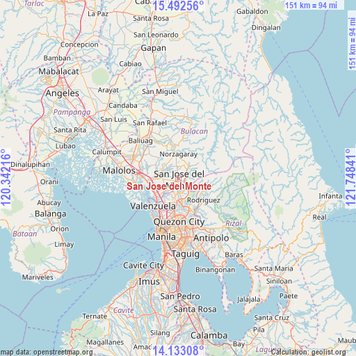
San Jose del Monte GPS coordinates[2]
14° 48' 50.004" North, 121° 2' 43.008" East
| Map corner | latitude | longitude |
|---|---|---|
| Upper-left | 15.49256°, | 120.34216° |
| Center: | 14.81389°, | 121.04528° |
| Lower-right: | 14.13308°, | 121.74841° |
| Map W x H: | 151.2×151.2 km | = 94×94mi |
| max Lat: | 20.78733° ⇑24.2% North |
| San Jose del Monte: | 14.81389° |
| min Lat: | ⇓75.8% South 4.65442° |
| min Long | San Jose del Mo | max Long |
| 117.04868° | 121.04528° | 126.58417° |
| W 24.7%⇐ | ⇒75.3% E |
Elevation
Elevation of San Jose del Monte is 56 m = 184 ft, and this is 31.9 m = 105 ft below average elevation for this country.
| Max E: |
2262 m = 7421 ft | 28.5% |
| Avg. | 87.9 m = 288 ft | |
| San Jose del Monte | 56 m = 184 ft | |
Min E: |
-2 m = -7 ft | 71.5% |
See also: San Jose del Monte elevation on elevation.city.
Geographical zone
San Jose del Monte is located in North Torrid zone (between Equator and Tropic of Cancer). Distance of this Northern Tropic circle is 958.8 km =595.8 mi to North.| Distance of | km | miles | from San Jose del Monte |
|---|---|---|---|
| North Pole | 8359.9 | 5194.6 | to North |
| Arctic Circle | 5754 | 3575.4 | to North |
| Tropic Cancer | 958.8 | 595.8 | to North |
| Equator | 1647.2 | 1023.5 | to South |


Nearby cities:
15 places around San Jose del Monte: (largest is in red/bold)
• Angat
12.8 km =8 mi,  352°
352°
• Bagong Barrio
14 km =8.7 mi,  307°
307°
• Balasing
5.7 km =3.5 mi,  322°
322°
• Bituñgol
7.8 km =4.8 mi, 350°
• Bocaue
12.9 km =8 mi,  262°
262°
• Guyong
7.6 km =4.7 mi,  288°
288°
• Loma de Gato
5.7 km =3.5 mi,  240°
240°
• Malanday
15 km =9.3 mi,  142°
142°
• Marilao
12.1 km =7.5 mi, 239°
• Meycauayan
12.5 km =7.8 mi,  226°
226°
• Norzagaray
10.8 km =6.7 mi,  2°
2°
• Pandi
11 km =6.8 mi,  300°
300°
• Santa Maria
8.8 km =5.5 mi,  275°
275°
• Sulucan
13 km =8.1 mi, 260°
• Valenzuela
15.2 km =9.4 mi,  213°
213°
In other languages:
- In Spanish: San José del Monte
- In German: San Jose del Monte City
- In Russian: Сан-Хосе-дель-Монте
Sources, notices
• [Note1] Compared only with cities in Philippines existing in our database
• [Src1] Map data: © OpenStreetMap contributors (CC-BY-SA)
• [Src2] Other city data from geonames.org with taken over terms of usage.
• [Src3] Geographical zone / Annual Mean Temperature by Robert A. Rohde @ Wikipedia
