Norzagaray geodata
Norzagaray (Central Luzon) is a populated place; located in Philippines in Asia/Manila (GMT+8) time zone. With population of 79,508 people, there are 115 cities with bigger population in this country. Compared to other cities in Philippines, 76.5% of cities are located further ↓South; 75.2% of cities are located further →East and 68.5% of cities have lower elevation than Norzagaray. Note1


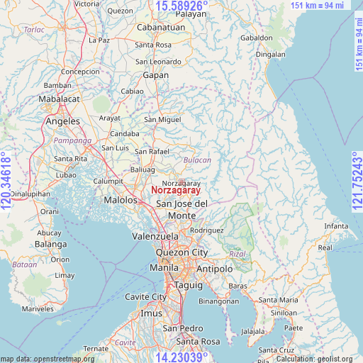
Norzagaray GPS coordinates[2]
14° 54' 39.24" North, 121° 2' 57.48" East
| Map corner | latitude | longitude |
|---|---|---|
| Upper-left | 15.58926°, | 120.34618° |
| Center: | 14.9109°, | 121.0493° |
| Lower-right: | 14.23039°, | 121.75243° |
| Map W x H: | 151.1×151.1 km | = 93.9×93.9mi |
| max Lat: | 20.78733° ⇑23.5% North |
| Norzagaray: | 14.9109° |
| min Lat: | ⇓76.5% South 4.65442° |
| min Long | Norzagaray | max Long |
| 117.04868° | 121.0493° | 126.58417° |
| W 24.8%⇐ | ⇒75.2% E |
Elevation
Elevation of Norzagaray is 49 m = 161 ft, and this is 38.9 m = 128 ft below average elevation for this country.
| Max E: |
2262 m = 7421 ft | 31.5% |
| Avg. | 87.9 m = 288 ft | |
| Norzagaray | 49 m = 161 ft | |
Min E: |
-2 m = -7 ft | 68.5% |
See also: Norzagaray elevation on elevation.city.
Geographical zone
Norzagaray is located in North Torrid zone (between Equator and Tropic of Cancer). Distance of this Northern Tropic circle is 948 km =589.1 mi to North.| Distance of | km | miles | from Norzagaray |
|---|---|---|---|
| North Pole | 8349.1 | 5187.9 | to North |
| Arctic Circle | 5743.2 | 3568.7 | to North |
| Tropic Cancer | 948 | 589.1 | to North |
| Equator | 1657.9 | 1030.2 | to South |


Nearby cities:
15 places around Norzagaray: (largest is in red/bold)
• Angat
2.9 km =1.8 mi,  313°
313°
• Bagong Barrio
11.9 km =7.4 mi,  258°
258°
• Balasing
7.4 km =4.6 mi,  212°
212°
• Bituñgol
3.5 km =2.2 mi, 209°
• Doña Remedios Trinidad
10.6 km =6.6 mi,  20°
20°
• Guyong
11.3 km =7 mi,  222°
222°
• Liciada
12.6 km =7.8 mi,  271°
271°
• Maasim
9.6 km =6 mi,  348°
348°
• Niugan
9.6 km =6 mi,  293°
293°
• Pandi
11.1 km =6.9 mi,  242°
242°
• Pantubig
12 km =7.5 mi,  302°
302°
• Pulo
6.8 km =4.2 mi,  326°
326°
• Pulong Sampalok
5.7 km =3.5 mi,  12°
12°
• San Jose del Monte
10.8 km =6.7 mi,  182°
182°
• San Rafael
10.2 km =6.3 mi, 293°
Sources, notices
• [Note1] Compared only with cities in Philippines existing in our database
• [Src1] Map data: © OpenStreetMap contributors (CC-BY-SA)
• [Src2] Other city data from geonames.org with taken over terms of usage.
• [Src3] Geographical zone / Annual Mean Temperature by Robert A. Rohde @ Wikipedia
