Balasing geodata
Balasing (Central Luzon) is a populated place; located in Philippines in Asia/Manila (GMT+8) time zone. With population of 4,768 people, there are 1389 cities with bigger population in this country. Compared to other cities in Philippines, 76% of cities are located further ↓South; 76% of cities are located further →East and 70% of cities have lower elevation than Balasing. Note1
Administrative division(s):
- Level 1: Central Luzon
- Level 2: Province of Bulacan
- Level 3: Santa Maria


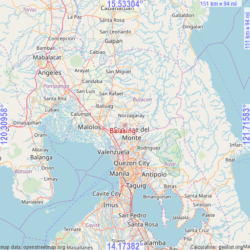
Balasing GPS coordinates[2]
14° 51' 16.2" North, 121° 0' 45.72" East
| Map corner | latitude | longitude |
|---|---|---|
| Upper-left | 15.53304°, | 120.30958° |
| Center: | 14.8545°, | 121.0127° |
| Lower-right: | 14.17382°, | 121.71583° |
| Map W x H: | 151.1×151.1 km | = 93.9×93.9mi |
| max Lat: | 20.78733° ⇑24% North |
| Balasing: | 14.8545° |
| min Lat: | ⇓76% South 4.65442° |
| min Long | Balasing | max Long |
| 117.04868° | 121.0127° | 126.58417° |
| W 24%⇐ | ⇒76% E |
Elevation
Elevation of Balasing is 52 m = 171 ft, and this is 35.9 m = 118 ft below average elevation for this country.
| Max E: |
2262 m = 7421 ft | 30% |
| Avg. | 87.9 m = 288 ft | |
| Balasing | 52 m = 171 ft | |
Min E: |
-2 m = -7 ft | 70% |
See also: Philippines elevation on elevation.city.
Geographical zone
Balasing is located in North Torrid zone (between Equator and Tropic of Cancer). Distance of this Northern Tropic circle is 954.3 km =593 mi to North.| Distance of | km | miles | from Balasing |
|---|---|---|---|
| North Pole | 8355.4 | 5191.8 | to North |
| Arctic Circle | 5749.5 | 3572.6 | to North |
| Tropic Cancer | 954.3 | 593 | to North |
| Equator | 1651.7 | 1026.3 | to South |


Nearby cities:
15 places around Balasing: (largest is in red/bold)
• Angat
8.4 km =5.2 mi,  12°
12°
• Bagong Barrio
8.7 km =5.4 mi,  297°
297°
• Bituñgol
3.9 km =2.4 mi,  34°
34°
• Bocaue
11.2 km =7 mi,  236°
236°
• Guyong
4.2 km =2.6 mi, 240°
• Liciada
11 km =6.8 mi,  307°
307°
• Loma de Gato
7.5 km =4.7 mi,  191°
191°
• Manatal
10.6 km =6.6 mi,  283°
283°
• Niugan
11.3 km =7 mi,  334°
334°
• Norzagaray
7.4 km =4.6 mi, 32°
• Pandi
6.1 km =3.8 mi, 281°
• Pulong Gubat
11.5 km =7.1 mi,  272°
272°
• San Jose del Monte
5.7 km =3.5 mi,  142°
142°
• Santa Maria
6.5 km =4 mi,  234°
234°
• Sulucan
11.5 km =7.1 mi, 234°
Sources, notices
• [Note1] Compared only with cities in Philippines existing in our database
• [Src1] Map data: © OpenStreetMap contributors (CC-BY-SA)
• [Src2] Other city data from geonames.org with taken over terms of usage.
• [Src3] Geographical zone / Annual Mean Temperature by Robert A. Rohde @ Wikipedia
