Sabtang geodata
Sabtang (Cagayan Valley) is a seat of a third-order administrative division; located in Philippines in Asia/Manila (GMT+8) time zone. In our database, there are 4166 cities with bigger population. Compared to other cities in Philippines, 99.9% of cities are located further ↓South; 61.8% of cities are located further →East and 67.4% of cities have higher elevation than Sabtang. Note1


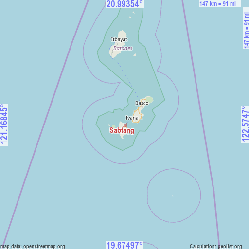
Sabtang GPS coordinates[2]
20° 20' 8.376" North, 121° 52' 17.652" East
| Map corner | latitude | longitude |
|---|---|---|
| Upper-left | 20.99354°, | 121.16845° |
| Center: | 20.33566°, | 121.87157° |
| Lower-right: | 19.67497°, | 122.5747° |
| Map W x H: | 146.6×146.6 km | = 91.1×91.1mi |
| max Lat: | 20.78733° ⇑0.1% North |
| Sabtang: | 20.33566° |
| min Lat: | ⇓99.9% South 4.65442° |
| min Long | Sabtang | max Long |
| 117.04868° | 121.87157° | 126.58417° |
| W 38.2%⇐ | ⇒61.8% E |
Elevation
Elevation of Sabtang is 13 m = 43 ft, and this is 74.9 m = 246 ft below average elevation for this country.
| Max E: |
2262 m = 7421 ft | 67.4% |
| Avg. | 87.9 m = 288 ft | |
| Sabtang | 13 m = 43 ft | |
Min E: |
-2 m = -7 ft | 32.6% |
See also: Philippines elevation on elevation.city.
Geographical zone
Sabtang is located in North Torrid zone (between Equator and Tropic of Cancer). Distance of this Northern Tropic circle is 344.8 km =214.2 mi to North.| Distance of | km | miles | from Sabtang |
|---|---|---|---|
| North Pole | 7745.9 | 4813.1 | to North |
| Arctic Circle | 5140.1 | 3193.9 | to North |
| Tropic Cancer | 344.8 | 214.2 | to North |
| Equator | 2261.1 | 1405 | to South |


Nearby cities:
15 places around Sabtang: (largest is in red/bold)
• Abulug
214.7 km =133.4 mi,  191°
191°
• Ballesteros
217.1 km =134.9 mi, 189°
• Basco
16.2 km =10.1 mi,  39°
39°
• Cabaritan East
217 km =134.8 mi, 190°
• Claveria
209.2 km =130 mi,  203°
203°
• Itbayat
50.3 km =31.3 mi,  356°
356°
• Ivana
5.9 km =3.7 mi,  49°
49°
• Mahatao
11.9 km =7.4 mi, 41°
• Namuac
205.6 km =127.8 mi, 201°
• Pamplona
215.2 km =133.7 mi, 194°
• San Vicente
205.4 km =127.6 mi,  171°
171°
• Santa Ana
209.5 km =130.2 mi, 172°
• Santa Cruz
210.7 km =130.9 mi, 196°
• Santa Praxedes
216.9 km =134.8 mi, 204°
• Uyugan
7.1 km =4.4 mi,  76°
76°
Sources, notices
• [Note1] Compared only with cities in Philippines existing in our database
• [Src1] Map data: © OpenStreetMap contributors (CC-BY-SA)
• [Src2] Other city data from geonames.org with taken over terms of usage.
• [Src3] Geographical zone / Annual Mean Temperature by Robert A. Rohde @ Wikipedia
