Burgos geodata
Burgos (Central Luzon) is a populated place; located in Philippines in Asia/Manila (GMT+8) time zone. With population of 28,178 people, there are 292 cities with bigger population in this country. Compared to other cities in Philippines, 84.2% of cities are located further ↓South; 89% of cities are located further →East and 54.5% of cities have higher elevation than Burgos. Note1


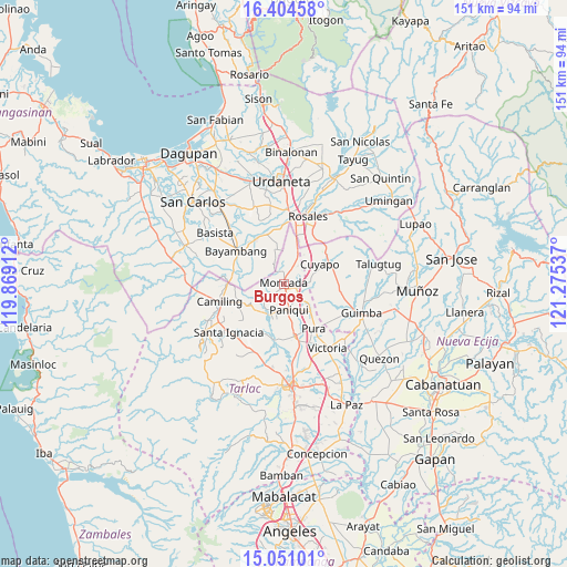
Burgos GPS coordinates[2]
15° 43' 44.112" North, 120° 34' 20.064" East
| Map corner | latitude | longitude |
|---|---|---|
| Upper-left | 16.40458°, | 119.86912° |
| Center: | 15.72892°, | 120.57224° |
| Lower-right: | 15.05101°, | 121.27537° |
| Map W x H: | 150.5×150.5 km | = 93.5×93.5mi |
| max Lat: | 20.78733° ⇑15.8% North |
| Burgos: | 15.72892° |
| min Lat: | ⇓84.2% South 4.65442° |
| min Long | Burgos | max Long |
| 117.04868° | 120.57224° | 126.58417° |
| W 11%⇐ | ⇒89% E |
Elevation
Elevation of Burgos is 20 m = 66 ft, and this is 67.9 m = 223 ft below average elevation for this country.
| Max E: |
2262 m = 7421 ft | 54.5% |
| Avg. | 87.9 m = 288 ft | |
| Burgos | 20 m = 66 ft | |
Min E: |
-2 m = -7 ft | 45.5% |
See also: Philippines elevation on elevation.city.
Geographical zone
Burgos is located in North Torrid zone (between Equator and Tropic of Cancer). Distance of this Northern Tropic circle is 857 km =532.5 mi to North.| Distance of | km | miles | from Burgos |
|---|---|---|---|
| North Pole | 8258.2 | 5131.4 | to North |
| Arctic Circle | 5652.3 | 3512.2 | to North |
| Tropic Cancer | 857 | 532.5 | to North |
| Equator | 1748.9 | 1086.7 | to South |


Nearby cities:
15 places around Burgos: (largest is in red/bold)
• Anao
5.7 km =3.5 mi,  89°
89°
• Balaoang
9.5 km =5.9 mi,  220°
220°
• Baquero Norte
2.4 km =1.5 mi,  233°
233°
• Bautista
10 km =6.2 mi,  307°
307°
• Cabayaoasan
7.6 km =4.7 mi,  197°
197°
• Estacion
5.1 km =3.2 mi,  130°
130°
• Lanat
7.8 km =4.8 mi,  26°
26°
• Moncada
0.7 km =0.4 mi,  14°
14°
• Nampicuan
5.7 km =3.5 mi, 87°
• Nancamarinan
7.1 km =4.4 mi,  212°
212°
• Pance
6.8 km =4.2 mi, 131°
• Paniqui
6.7 km =4.2 mi,  172°
172°
• San Manuel
8.7 km =5.4 mi, 26°
• Sapang
5.9 km =3.7 mi,  240°
240°
• Villanueva
8.2 km =5.1 mi,  340°
340°
Sources, notices
• [Note1] Compared only with cities in Philippines existing in our database
• [Src1] Map data: © OpenStreetMap contributors (CC-BY-SA)
• [Src2] Other city data from geonames.org with taken over terms of usage.
• [Src3] Geographical zone / Annual Mean Temperature by Robert A. Rohde @ Wikipedia
