Baquero Norte geodata
Baquero Norte (Central Luzon) is a populated place; located in Philippines in Asia/Manila (GMT+8) time zone. With population of 5,145 people, there are 1244 cities with bigger population in this country. Compared to other cities in Philippines, 84% of cities are located further ↓South; 89.5% of cities are located further →East and 52.3% of cities have lower elevation than Baquero Norte. Note1


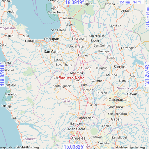
Baquero Norte GPS coordinates[2]
15° 42' 58.32" North, 120° 33' 15.48" East
| Map corner | latitude | longitude |
|---|---|---|
| Upper-left | 16.3919°, | 119.85118° |
| Center: | 15.7162°, | 120.5543° |
| Lower-right: | 15.03825°, | 121.25743° |
| Map W x H: | 150.5×150.5 km | = 93.5×93.5mi |
| max Lat: | 20.78733° ⇑16% North |
| Baquero Norte: | 15.7162° |
| min Lat: | ⇓84% South 4.65442° |
| min Long | Baquero Norte | max Long |
| 117.04868° | 120.5543° | 126.58417° |
| W 10.5%⇐ | ⇒89.5% E |
Elevation
Elevation of Baquero Norte is 25 m = 82 ft, and this is 62.9 m = 206 ft below average elevation for this country.
| Max E: |
2262 m = 7421 ft | 47.7% |
| Avg. | 87.9 m = 288 ft | |
| Baquero Norte | 25 m = 82 ft | |
Min E: |
-2 m = -7 ft | 52.3% |
See also: Philippines elevation on elevation.city.
Geographical zone
Baquero Norte is located in North Torrid zone (between Equator and Tropic of Cancer). Distance of this Northern Tropic circle is 858.4 km =533.4 mi to North.| Distance of | km | miles | from Baquero Norte |
|---|---|---|---|
| North Pole | 8259.6 | 5132.3 | to North |
| Arctic Circle | 5653.7 | 3513 | to North |
| Tropic Cancer | 858.4 | 533.4 | to North |
| Equator | 1747.5 | 1085.8 | to South |


Nearby cities:
15 places around Baquero Norte: (largest is in red/bold)
• Anao
7.7 km =4.8 mi,  79°
79°
• Balaoang
7.3 km =4.5 mi,  215°
215°
• Bautista
9.6 km =6 mi,  321°
321°
• Burgos
2.4 km =1.5 mi,  53°
53°
• Cabayaoasan
5.9 km =3.7 mi,  183°
183°
• Estacion
6.1 km =3.8 mi,  107°
107°
• Lanat
10 km =6.2 mi,  32°
32°
• Mabilang
8.4 km =5.2 mi,  237°
237°
• Moncada
3 km =1.9 mi,  44°
44°
• Nampicuan
7.8 km =4.8 mi, 77°
• Nancamarinan
4.9 km =3 mi,  202°
202°
• Pance
7.7 km =4.8 mi, 113°
• Paniqui
6 km =3.7 mi,  151°
151°
• Sapang
3.5 km =2.2 mi,  245°
245°
• Villanueva
9.2 km =5.7 mi,  354°
354°
Sources, notices
• [Note1] Compared only with cities in Philippines existing in our database
• [Src1] Map data: © OpenStreetMap contributors (CC-BY-SA)
• [Src2] Other city data from geonames.org with taken over terms of usage.
• [Src3] Geographical zone / Annual Mean Temperature by Robert A. Rohde @ Wikipedia
