Maluñgun geodata
Maluñgun (Soccsksargen) is a populated place; located in Philippines in Asia/Manila (GMT+8) time zone. With population of 52,248 people, there are 172 cities with bigger population in this country. Compared to other cities in Philippines, 96.8% of cities are located further ↑North; 91.1% of cities are located further ←West and 84.4% of cities have lower elevation than Maluñgun. Note1


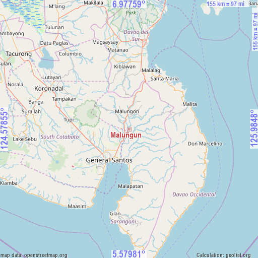
Maluñgun GPS coordinates[2]
6° 16' 45.012" North, 125° 16' 54.012" East
| Map corner | latitude | longitude |
|---|---|---|
| Upper-left | 6.97759°, | 124.57855° |
| Center: | 6.27917°, | 125.28167° |
| Lower-right: | 5.57981°, | 125.9848° |
| Map W x H: | 155.4×155.4 km | = 96.6×96.6mi |
| max Lat: | 20.78733° ⇑96.8% North |
| Maluñgun: | 6.27917° |
| min Lat: | ⇓3.2% South 4.65442° |
| min Long | Maluñgun | max Long |
| 117.04868° | 125.28167° | 126.58417° |
| W 91.1%⇐ | ⇒8.9% E |
Elevation
Elevation of Maluñgun is 127 m = 417 ft, and this is 39.1 m = 128 ft above average elevation for this country.
| Max E: |
2262 m = 7421 ft | 15.6% |
| Maluñgun | 127 m 417 ft | |
| Avg. | 87.9 m = 288 ft | |
Min E: |
-2 m = -7 ft | 84.4% |
See also: Maluñgun elevation on elevation.city.
Geographical zone
Maluñgun is located in North Torrid zone (between Equator and Tropic of Cancer). Distance of Equator is 698.2 km =433.8 mi to South.| Distance of | km | miles | from Maluñgun |
|---|---|---|---|
| North Pole | 9308.9 | 5784.3 | to North |
| Arctic Circle | 6703 | 4165 | to North |
| Tropic Cancer | 1907.7 | 1185.4 | to North |
| Equator | 698.2 | 433.8 | to South |


Nearby cities:
15 places around Maluñgun: (largest is in red/bold)
• Alabel
19.7 km =12.2 mi,  177°
177°
• Batutitik
7 km =4.3 mi,  207°
207°
• Buayan
18.8 km =11.7 mi,  195°
195°
• Conel
13.5 km =8.4 mi,  230°
230°
• General Santos
22.1 km =13.7 mi, 213°
• Glamang
25.4 km =15.8 mi,  239°
239°
• Katangawan
13.6 km =8.5 mi, 209°
• Klinan
19 km =11.8 mi, 237°
• Malandag
5.1 km =3.2 mi,  312°
312°
• Manga
3.2 km =2 mi,  66°
66°
• Polo
18.8 km =11.7 mi,  265°
265°
• Polomolok
24.9 km =15.5 mi,  255°
255°
• Silway 7
21.1 km =13.1 mi, 237°
• Tinagacan
10.6 km =6.6 mi, 212°
• Upper Klinan
18.7 km =11.6 mi,  251°
251°
Sources, notices
• [Note1] Compared only with cities in Philippines existing in our database
• [Src1] Map data: © OpenStreetMap contributors (CC-BY-SA)
• [Src2] Other city data from geonames.org with taken over terms of usage.
• [Src3] Geographical zone / Annual Mean Temperature by Robert A. Rohde @ Wikipedia
