Dangcalan geodata
Dangcalan (Bicol) is a populated place; located in Philippines in Asia/Manila (GMT+8) time zone. With population of 2,167 people, there are 3957 cities with bigger population in this country. Compared to other cities in Philippines, 56.9% of cities are located further ↓South; 63.7% of cities are located further ←West and 89.7% of cities have higher elevation than Dangcalan. Note1


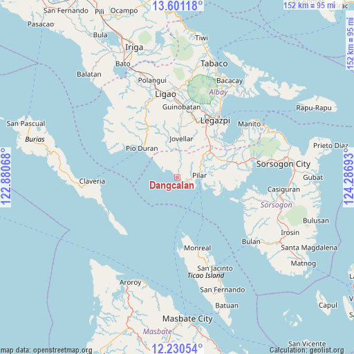
Dangcalan GPS coordinates[2]
12° 55' 0.48" North, 123° 35' 1.68" East
| Map corner | latitude | longitude |
|---|---|---|
| Upper-left | 13.60118°, | 122.88068° |
| Center: | 12.9168°, | 123.5838° |
| Lower-right: | 12.23054°, | 124.28693° |
| Map W x H: | 152.4×152.4 km | = 94.7×94.7mi |
| max Lat: | 20.78733° ⇑43.1% North |
| Dangcalan: | 12.9168° |
| min Lat: | ⇓56.9% South 4.65442° |
| min Long | Dangcalan | max Long |
| 117.04868° | 123.5838° | 126.58417° |
| W 63.7%⇐ | ⇒36.3% E |
Elevation
Elevation of Dangcalan is 7 m = 23 ft, and this is 80.9 m = 265 ft below average elevation for this country.
| Max E: |
2262 m = 7421 ft | 89.7% |
| Avg. | 87.9 m = 288 ft | |
| Dangcalan | 7 m = 23 ft | |
Min E: |
-2 m = -7 ft | 10.3% |
See also: Philippines elevation on elevation.city.
Geographical zone
Dangcalan is located in North Torrid zone (between Equator and Tropic of Cancer). Distance of this Northern Tropic circle is 1169.7 km =726.8 mi to North.| Distance of | km | miles | from Dangcalan |
|---|---|---|---|
| North Pole | 8570.8 | 5325.6 | to North |
| Arctic Circle | 5965 | 3706.5 | to North |
| Tropic Cancer | 1169.7 | 726.8 | to North |
| Equator | 1436.2 | 892.4 | to South |


Nearby cities:
15 places around Dangcalan: (largest is in red/bold)
• Aanislag
21.8 km =13.5 mi,  36°
36°
• Abucay
10.1 km =6.3 mi, 44°
• Binodegahan
21.1 km =13.1 mi,  319°
319°
• Cabiguan
16 km =9.9 mi,  94°
94°
• Donsol
1.7 km =1.1 mi,  136°
136°
• Jovellar
17.1 km =10.6 mi,  5°
5°
• Macalaya
20.5 km =12.7 mi,  98°
98°
• Malidong
17.2 km =10.7 mi,  308°
308°
• Ogod
4 km =2.5 mi,  116°
116°
• Pilar
9.6 km =6 mi, 85°
• Pio Duran
19.6 km =12.2 mi, 309°
• Putiao
18.2 km =11.3 mi,  51°
51°
• Salvacion
17 km =10.6 mi, 12°
• San Rafael
11.1 km =6.9 mi,  105°
105°
• Villahermosa
20.1 km =12.5 mi, 44°
Sources, notices
• [Note1] Compared only with cities in Philippines existing in our database
• [Src1] Map data: © OpenStreetMap contributors (CC-BY-SA)
• [Src2] Other city data from geonames.org with taken over terms of usage.
• [Src3] Geographical zone / Annual Mean Temperature by Robert A. Rohde @ Wikipedia
