Rojhan geodata
Rojhan (Punjab) is a populated place; located in Pakistan in Asia/Karachi (GMT+5) time zone. With population of 13,031 people, there are 332 cities with bigger population in this country. Compared to other cities in Pakistan, 67.5% of cities are located further ↑North; 62.8% of cities are located further →East and 69.8% of cities have higher elevation than Rojhan. Note1


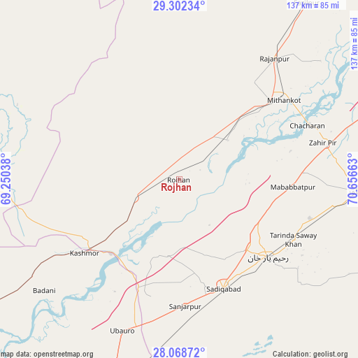
Rojhan GPS coordinates[2]
28° 41' 14.46" North, 69° 57' 12.6" East
| Map corner | latitude | longitude |
|---|---|---|
| Upper-left | 29.30234°, | 69.25038° |
| Center: | 28.68735°, | 69.9535° |
| Lower-right: | 28.06872°, | 70.65663° |
| Map W x H: | 137.2×137.2 km | = 85.3×85.3mi |
| max Lat: | 36.32162° ⇑67.5% North |
| Rojhan: | 28.68735° |
| min Lat: | ⇓32.5% South 24.14422° |
| min Long | Rojhan | max Long |
| 61.74573° | 69.9535° | 75.63372° |
| W 37.2%⇐ | ⇒62.8% E |
Elevation
Elevation of Rojhan is 88 m = 289 ft, and this is 257 m = 843 ft below average elevation for this country.
| Max E: |
2732 m = 8963 ft | 69.8% |
| Avg. | 345 m = 1132 ft | |
| Rojhan | 88 m = 289 ft | |
Min E: |
3 m = 10 ft | 30.2% |
See also: Pakistan elevation on elevation.city.
Geographical zone
Rojhan is located in North temperate zone (between Tropic of Cancer and the Arctic Circle). Distance of this Northern Tropic circle is 583.8 km =362.8 mi to South.| Distance of | km | miles | from Rojhan |
|---|---|---|---|
| North Pole | 6817.3 | 4236.1 | to North |
| Arctic Circle | 4211.4 | 2616.8 | to North |
| Tropic Cancer | 583.8 | 362.8 | to South |
| Equator | 3189.7 | 1982 | to South |


Nearby cities:
15 places around Rojhan: (largest is in red/bold)
• Adilpur
104 km =64.6 mi,  216°
216°
• Dera Bugti
86.6 km =53.8 mi,  296°
296°
• Ghotki
98.3 km =61.1 mi, 219°
• Kandhkot
90.2 km =56 mi,  237°
237°
• Kashmor
45.9 km =28.5 mi,  231°
231°
• Khairpur
73.5 km =45.7 mi,  199°
199°
• Khanpur
68.8 km =42.8 mi,  93°
93°
• Kot Samaba
52.5 km =32.6 mi,  106°
106°
• Mirpur Mathelo
84 km =52.2 mi,  208°
208°
• Rahim Yar Khan
45.3 km =28.1 mi,  131°
131°
• Rajanpur
59.1 km =36.7 mi,  38°
38°
• Saddiqabad
45.3 km =28.1 mi,  158°
158°
• Tangwani
103.9 km =64.6 mi, 244°
• Ubauro
62.1 km =38.6 mi, 200°
• Zahir Pir
57.3 km =35.6 mi,  75°
75°
Sources, notices
• [Note1] Compared only with cities in Pakistan existing in our database
• [Src1] Map data: © OpenStreetMap contributors (CC-BY-SA)
• [Src2] Other city data from geonames.org with taken over terms of usage.
• [Src3] Geographical zone / Annual Mean Temperature by Robert A. Rohde @ Wikipedia
