Ratodero geodata
Ratodero (Sindh) is a populated place; located in Pakistan in Asia/Karachi (GMT+5) time zone. With population of 47,819 people, there are 135 cities with bigger population in this country. Compared to other cities in Pakistan, 75.4% of cities are located further ↑North; 83.1% of cities are located further →East and 76.3% of cities have higher elevation than Ratodero. Note1


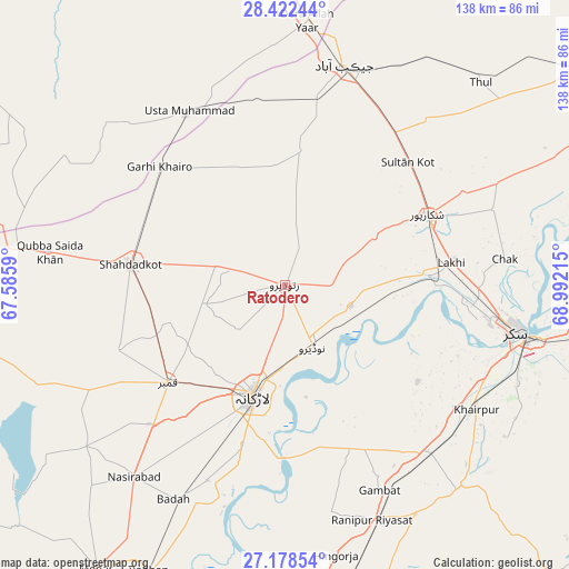
Ratodero GPS coordinates[2]
27° 48' 8.172" North, 68° 17' 20.472" East
| Map corner | latitude | longitude |
|---|---|---|
| Upper-left | 28.42244°, | 67.5859° |
| Center: | 27.80227°, | 68.28902° |
| Lower-right: | 27.17854°, | 68.99215° |
| Map W x H: | 138.3×138.3 km | = 85.9×85.9mi |
| max Lat: | 36.32162° ⇑75.4% North |
| Ratodero: | 27.80227° |
| min Lat: | ⇓24.6% South 24.14422° |
| min Long | Ratodero | max Long |
| 61.74573° | 68.28902° | 75.63372° |
| W 16.9%⇐ | ⇒83.1% E |
Elevation
Elevation of Ratodero is 60 m = 197 ft, and this is 285 m = 935 ft below average elevation for this country.
| Max E: |
2732 m = 8963 ft | 76.3% |
| Avg. | 345 m = 1132 ft | |
| Ratodero | 60 m = 197 ft | |
Min E: |
3 m = 10 ft | 23.7% |
See also: Ratodero elevation on elevation.city.
Geographical zone
Ratodero is located in North temperate zone (between Tropic of Cancer and the Arctic Circle). Distance of this Northern Tropic circle is 485.4 km =301.6 mi to South.| Distance of | km | miles | from Ratodero |
|---|---|---|---|
| North Pole | 6915.7 | 4297.2 | to North |
| Arctic Circle | 4309.9 | 2678 | to North |
| Tropic Cancer | 485.4 | 301.6 | to South |
| Equator | 3091.3 | 1920.8 | to South |


Nearby cities:
15 places around Ratodero: (largest is in red/bold)
• Bagarji
46.5 km =28.9 mi,  96°
96°
• Chowki Jamali
43.5 km =27 mi,  303°
303°
• Garhi Khairo
41.7 km =25.9 mi,  313°
313°
• Garhiyasin
24.8 km =15.4 mi,  62°
62°
• Goth Garelo
45.9 km =28.5 mi,  207°
207°
• Kambar
37.1 km =23.1 mi,  229°
229°
• Lakhi
40.7 km =25.3 mi,  82°
82°
• Larkana
28.1 km =17.5 mi,  195°
195°
• Madeji
16.9 km =10.5 mi,  108°
108°
• Mehrabpur
42.7 km =26.5 mi,  322°
322°
• Miro Khan
20 km =12.4 mi,  256°
256°
• Naudero
16.6 km =10.3 mi,  154°
154°
• Pir Jo Goth
40 km =24.9 mi,  125°
125°
• Shahdad Kot
37.9 km =23.5 mi,  277°
277°
• Shikarpur
38.3 km =23.8 mi, 63°
Sources, notices
• [Note1] Compared only with cities in Pakistan existing in our database
• [Src1] Map data: © OpenStreetMap contributors (CC-BY-SA)
• [Src2] Other city data from geonames.org with taken over terms of usage.
• [Src3] Geographical zone / Annual Mean Temperature by Robert A. Rohde @ Wikipedia
