Fazilpur geodata
Fazilpur (Punjab) is a populated place; located in Pakistan in Asia/Karachi (GMT+5) time zone. With population of 28,213 people, there are 218 cities with bigger population in this country. Compared to other cities in Pakistan, 68.4% of cities are located further ↓South; 99.5% of cities are located further ←West and 70.9% of cities have lower elevation than Fazilpur. Note1


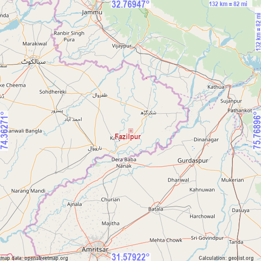
Fazilpur GPS coordinates[2]
32° 10' 34.644" North, 75° 3' 56.988" East
| Map corner | latitude | longitude |
|---|---|---|
| Upper-left | 32.76947°, | 74.36271° |
| Center: | 32.17629°, | 75.06583° |
| Lower-right: | 31.57922°, | 75.76896° |
| Map W x H: | 132.3×132.3 km | = 82.2×82.2mi |
| max Lat: | 36.32162° ⇑31.6% North |
| Fazilpur: | 32.17629° |
| min Lat: | ⇓68.4% South 24.14422° |
| min Long | Fazilpur | max Long |
| 61.74573° | 75.06583° | 75.63372° |
| W 99.5%⇐ | ⇒0.5% E |
Elevation
Elevation of Fazilpur is 248 m = 814 ft, and this is 97 m = 318 ft below average elevation for this country.
| Max E: |
2732 m = 8963 ft | 29.1% |
| Avg. | 345 m = 1132 ft | |
| Fazilpur | 248 m = 814 ft | |
Min E: |
3 m = 10 ft | 70.9% |
See also: Pakistan elevation on elevation.city.
Geographical zone
Fazilpur is located in North temperate zone (between Tropic of Cancer and the Arctic Circle). Distance of this Northern Tropic circle is 971.7 km =603.8 mi to South.| Distance of | km | miles | from Fazilpur |
|---|---|---|---|
| North Pole | 6429.4 | 3995 | to North |
| Arctic Circle | 3823.5 | 2375.8 | to North |
| Tropic Cancer | 971.7 | 603.8 | to South |
| Equator | 3577.7 | 2223.1 | to South |


Nearby cities:
15 places around Fazilpur: (largest is in red/bold)
• Baddomalhi
43.1 km =26.8 mi,  241°
241°
• Bhopalwala
71.8 km =44.6 mi,  293°
293°
• Chawinda
38.7 km =24 mi,  298°
298°
• Daska Kalan
69.3 km =43.1 mi,  283°
283°
• Hadali
69.6 km =43.2 mi,  317°
317°
• Kalaswala
39.4 km =24.5 mi,  273°
273°
• Kot Ghulam Muhammad
51.8 km =32.2 mi, 289°
• Kot Rajkour
48.7 km =30.3 mi, 302°
• Kotli Loharan
70.6 km =43.9 mi,  310°
310°
• Narang Mandi
60 km =37.3 mi, 239°
• Narowal
19.9 km =12.4 mi,  245°
245°
• Pasrur
39.1 km =24.3 mi, 284°
• Shakargarh
13.1 km =8.1 mi,  42°
42°
• Sialkot
61.3 km =38.1 mi, 305°
• Zafarwal
24.4 km =15.2 mi, 320°
Sources, notices
• [Note1] Compared only with cities in Pakistan existing in our database
• [Src1] Map data: © OpenStreetMap contributors (CC-BY-SA)
• [Src2] Other city data from geonames.org with taken over terms of usage.
• [Src3] Geographical zone / Annual Mean Temperature by Robert A. Rohde @ Wikipedia
