Kambar geodata
Kambar (Sindh) is a populated place; located in Pakistan in Asia/Karachi (GMT+5) time zone. With population of 77,481 people, there are 83 cities with bigger population in this country. Compared to other cities in Pakistan, 77.2% of cities are located further ↑North; 87.6% of cities are located further →East and 80.4% of cities have higher elevation than Kambar. Note1


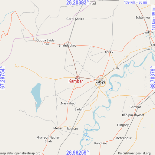
Kambar GPS coordinates[2]
27° 35' 15.108" North, 68° 0' 2.376" East
| Map corner | latitude | longitude |
|---|---|---|
| Upper-left | 28.20893°, | 67.29754° |
| Center: | 27.58753°, | 68.00066° |
| Lower-right: | 26.96259°, | 68.70379° |
| Map W x H: | 138.6×138.6 km | = 86.1×86.1mi |
| max Lat: | 36.32162° ⇑77.2% North |
| Kambar: | 27.58753° |
| min Lat: | ⇓22.8% South 24.14422° |
| min Long | Kambar | max Long |
| 61.74573° | 68.00066° | 75.63372° |
| W 12.4%⇐ | ⇒87.6% E |
Elevation
Elevation of Kambar is 53 m = 174 ft, and this is 292 m = 958 ft below average elevation for this country.
| Max E: |
2732 m = 8963 ft | 80.4% |
| Avg. | 345 m = 1132 ft | |
| Kambar | 53 m = 174 ft | |
Min E: |
3 m = 10 ft | 19.6% |
See also: Kambar elevation on elevation.city.
Geographical zone
Kambar is located in North temperate zone (between Tropic of Cancer and the Arctic Circle). Distance of this Northern Tropic circle is 461.5 km =286.8 mi to South.| Distance of | km | miles | from Kambar |
|---|---|---|---|
| North Pole | 6939.6 | 4312.1 | to North |
| Arctic Circle | 4333.7 | 2692.8 | to North |
| Tropic Cancer | 461.5 | 286.8 | to South |
| Equator | 3067.4 | 1906 | to South |


Nearby cities:
15 places around Kambar: (largest is in red/bold)
• Chowki Jamali
48.7 km =30.3 mi,  350°
350°
• Dokri
25.6 km =15.9 mi,  158°
158°
• Goth Garelo
18.5 km =11.5 mi, 156°
• Goth Radhan
43.5 km =27 mi,  186°
186°
• Larkana
21.1 km =13.1 mi,  98°
98°
• Madeji
48.1 km =29.9 mi,  67°
67°
• Mehar
48.7 km =30.3 mi,  201°
201°
• Miro Khan
21.2 km =13.2 mi,  25°
25°
• Nasirabad
24.4 km =15.2 mi, 199°
• Naudero
36.6 km =22.7 mi,  76°
76°
• New Bādāh
27.5 km =17.1 mi,  173°
173°
• Ratodero
37.1 km =23.1 mi,  49°
49°
• Shahdad Kot
30.3 km =18.8 mi,  342°
342°
• Sobhodero
50.2 km =31.2 mi,  128°
128°
• Warah
25.4 km =15.8 mi,  232°
232°
Sources, notices
• [Note1] Compared only with cities in Pakistan existing in our database
• [Src1] Map data: © OpenStreetMap contributors (CC-BY-SA)
• [Src2] Other city data from geonames.org with taken over terms of usage.
• [Src3] Geographical zone / Annual Mean Temperature by Robert A. Rohde @ Wikipedia
