Kalabagh geodata
Kalabagh (Punjab) is a populated place; located in Pakistan in Asia/Karachi (GMT+5) time zone. With population of 15,976 people, there are 304 cities with bigger population in this country. Compared to other cities in Pakistan, 82.4% of cities are located further ↓South; 50.6% of cities are located further ←West and 64.8% of cities have lower elevation than Kalabagh. Note1


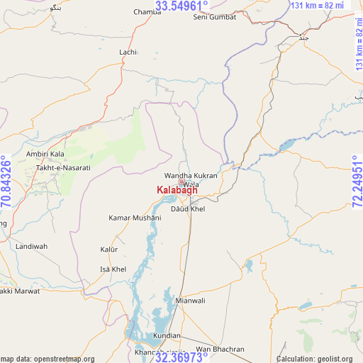
Kalabagh GPS coordinates[2]
32° 57' 41.904" North, 71° 32' 46.968" East
| Map corner | latitude | longitude |
|---|---|---|
| Upper-left | 33.54961°, | 70.84326° |
| Center: | 32.96164°, | 71.54638° |
| Lower-right: | 32.36973°, | 72.24951° |
| Map W x H: | 131.2×131.2 km | = 81.5×81.5mi |
| max Lat: | 36.32162° ⇑17.6% North |
| Kalabagh: | 32.96164° |
| min Lat: | ⇓82.4% South 24.14422° |
| min Long | Kalabagh | max Long |
| 61.74573° | 71.54638° | 75.63372° |
| W 50.6%⇐ | ⇒49.4% E |
Elevation
Elevation of Kalabagh is 218 m = 715 ft, and this is 127 m = 417 ft below average elevation for this country.
| Max E: |
2732 m = 8963 ft | 35.2% |
| Avg. | 345 m = 1132 ft | |
| Kalabagh | 218 m = 715 ft | |
Min E: |
3 m = 10 ft | 64.8% |
See also: Pakistan elevation on elevation.city.
Geographical zone
Kalabagh is located in North temperate zone (between Tropic of Cancer and the Arctic Circle). Distance of this Northern Tropic circle is 1059.1 km =658.1 mi to South.| Distance of | km | miles | from Kalabagh |
|---|---|---|---|
| North Pole | 6342.1 | 3940.8 | to North |
| Arctic Circle | 3736.2 | 2321.6 | to North |
| Tropic Cancer | 1059.1 | 658.1 | to South |
| Equator | 3665 | 2277.3 | to South |


Nearby cities:
15 places around Kalabagh: (largest is in red/bold)
• Bannu
87.9 km =54.6 mi,  271°
271°
• Daud Khel
9.9 km =6.2 mi,  166°
166°
• Hangu
77.9 km =48.4 mi,  324°
324°
• Harnoli
75.9 km =47.2 mi,  179°
179°
• Jand
68.4 km =42.5 mi,  39°
39°
• Kamar Mushani
21.7 km =13.5 mi,  232°
232°
• Karak
45.6 km =28.3 mi,  292°
292°
• Kohat
69.6 km =43.2 mi,  352°
352°
• Kundian
56.4 km =35 mi,  186°
186°
• Lachi
50.7 km =31.5 mi,  337°
337°
• Lakki
71.2 km =44.2 mi,  236°
236°
• Mianwali
42.7 km =26.5 mi, 182°
• Pindi Gheb
73.8 km =45.9 mi,  65°
65°
• Sarai Naurang
73 km =45.4 mi,  258°
258°
• Talagang
81.2 km =50.5 mi,  92°
92°
Sources, notices
• [Note1] Compared only with cities in Pakistan existing in our database
• [Src1] Map data: © OpenStreetMap contributors (CC-BY-SA)
• [Src2] Other city data from geonames.org with taken over terms of usage.
• [Src3] Geographical zone / Annual Mean Temperature by Robert A. Rohde @ Wikipedia
