Doaba geodata
Doaba (Khyber Pakhtunkhwa) is a populated place; located in Pakistan in Asia/Karachi (GMT+5) time zone. With population of 8,893 people, there are 361 cities with bigger population in this country. Compared to other cities in Pakistan, 84.9% of cities are located further ↓South; 58.5% of cities are located further →East and 87.1% of cities have lower elevation than Doaba. Note1


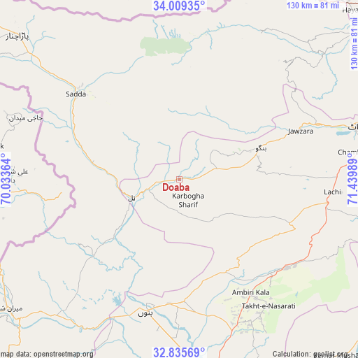
Doaba GPS coordinates[2]
33° 25' 28.2" North, 70° 44' 12.336" East
| Map corner | latitude | longitude |
|---|---|---|
| Upper-left | 34.00935°, | 70.03364° |
| Center: | 33.4245°, | 70.73676° |
| Lower-right: | 32.83569°, | 71.43989° |
| Map W x H: | 130.5×130.5 km | = 81.1×81.1mi |
| max Lat: | 36.32162° ⇑15.1% North |
| Doaba: | 33.4245° |
| min Lat: | ⇓84.9% South 24.14422° |
| min Long | Doaba | max Long |
| 61.74573° | 70.73676° | 75.63372° |
| W 41.5%⇐ | ⇒58.5% E |
Elevation
Elevation of Doaba is 890 m = 2920 ft, and this is 545 m = 1788 ft above average elevation for this country.
| Max E: |
2732 m = 8963 ft | 12.9% |
| Doaba | 890 m 2920 ft | |
| Avg. | 345 m = 1132 ft | |
Min E: |
3 m = 10 ft | 87.1% |
See also: Pakistan elevation on elevation.city.
Geographical zone
Doaba is located in North temperate zone (between Tropic of Cancer and the Arctic Circle). Distance of this Northern Tropic circle is 1110.5 km =690 mi to South.| Distance of | km | miles | from Doaba |
|---|---|---|---|
| North Pole | 6290.6 | 3908.8 | to North |
| Arctic Circle | 3684.7 | 2289.6 | to North |
| Tropic Cancer | 1110.5 | 690 | to South |
| Equator | 3716.5 | 2309.3 | to South |


Nearby cities:
15 places around Doaba: (largest is in red/bold)
• Alizai
38.3 km =23.8 mi,  288°
288°
• Bannu
50.4 km =31.3 mi,  194°
194°
• Daud Khel
98.8 km =61.4 mi,  128°
128°
• Gulishah Kach
91.6 km =56.9 mi,  203°
203°
• Hangu
32.2 km =20 mi,  68°
68°
• Kalabagh
91.2 km =56.7 mi,  124°
124°
• Kamar Mushani
87 km =54.1 mi,  137°
137°
• Karak
47.7 km =29.6 mi, 135°
• Kohat
68.3 km =42.4 mi,  75°
75°
• Lachi
55.9 km =34.7 mi,  94°
94°
• Lakki
92.3 km =57.4 mi,  169°
169°
• Landi Kotal
83.8 km =52.1 mi,  26°
26°
• Miran Shah
77.8 km =48.3 mi,  232°
232°
• Parachinar
79.1 km =49.2 mi,  311°
311°
• Sarai Naurang
66.7 km =41.4 mi,  176°
176°
Sources, notices
• [Note1] Compared only with cities in Pakistan existing in our database
• [Src1] Map data: © OpenStreetMap contributors (CC-BY-SA)
• [Src2] Other city data from geonames.org with taken over terms of usage.
• [Src3] Geographical zone / Annual Mean Temperature by Robert A. Rohde @ Wikipedia
