Karak geodata
Karak (Khyber Pakhtunkhwa) is a seat of a second-order administrative division; located in Pakistan in Asia/Karachi (GMT+5) time zone. With population of 13,679 people, there are 327 cities with bigger population in this country. Compared to other cities in Pakistan, 83.3% of cities are located further ↓South; 53.7% of cities are located further →East and 83.7% of cities have lower elevation than Karak. Note1


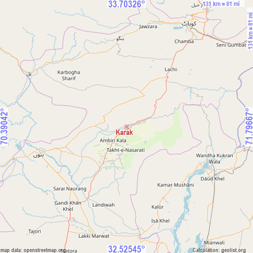
Karak GPS coordinates[2]
33° 6' 58.788" North, 71° 5' 36.744" East
| Map corner | latitude | longitude |
|---|---|---|
| Upper-left | 33.70326°, | 70.39042° |
| Center: | 33.11633°, | 71.09354° |
| Lower-right: | 32.52545°, | 71.79667° |
| Map W x H: | 131×131 km | = 81.4×81.4mi |
| max Lat: | 36.32162° ⇑16.7% North |
| Karak: | 33.11633° |
| min Lat: | ⇓83.3% South 24.14422° |
| min Long | Karak | max Long |
| 61.74573° | 71.09354° | 75.63372° |
| W 46.3%⇐ | ⇒53.7% E |
Elevation
Elevation of Karak is 582 m = 1909 ft, and this is 237 m = 778 ft above average elevation for this country.
| Max E: |
2732 m = 8963 ft | 16.3% |
| Karak | 582 m 1909 ft | |
| Avg. | 345 m = 1132 ft | |
Min E: |
3 m = 10 ft | 83.7% |
See also: Pakistan elevation on elevation.city.
Geographical zone
Karak is located in North temperate zone (between Tropic of Cancer and the Arctic Circle). Distance of this Northern Tropic circle is 1076.3 km =668.8 mi to South.| Distance of | km | miles | from Karak |
|---|---|---|---|
| North Pole | 6324.9 | 3930.1 | to North |
| Arctic Circle | 3719 | 2310.9 | to North |
| Tropic Cancer | 1076.3 | 668.8 | to South |
| Equator | 3682.2 | 2288 | to South |


Nearby cities:
15 places around Karak: (largest is in red/bold)
• Alizai
83.7 km =52 mi,  303°
303°
• Bannu
47.9 km =29.8 mi,  252°
252°
• Daud Khel
52 km =32.3 mi,  121°
121°
• Doaba
47.7 km =29.6 mi,  315°
315°
• Gulishah Kach
86.1 km =53.5 mi,  234°
234°
• Hangu
46.3 km =28.8 mi,  356°
356°
• Jand
92.9 km =57.7 mi,  67°
67°
• Kalabagh
45.6 km =28.3 mi,  112°
112°
• Kamar Mushani
39.4 km =24.5 mi,  140°
140°
• Kohat
61.4 km =38.2 mi,  32°
32°
• Kundian
81.6 km =50.7 mi,  153°
153°
• Lachi
37.3 km =23.2 mi,  37°
37°
• Lakki
59.1 km =36.7 mi,  196°
196°
• Mianwali
72.4 km =45 mi, 145°
• Sarai Naurang
43.5 km =27 mi,  222°
222°
Sources, notices
• [Note1] Compared only with cities in Pakistan existing in our database
• [Src1] Map data: © OpenStreetMap contributors (CC-BY-SA)
• [Src2] Other city data from geonames.org with taken over terms of usage.
• [Src3] Geographical zone / Annual Mean Temperature by Robert A. Rohde @ Wikipedia
