Tandlianwala geodata
Tandlianwala (Punjab) is a populated place; located in Pakistan in Asia/Karachi (GMT+5) time zone. With population of 38,285 people, there are 162 cities with bigger population in this country. Compared to other cities in Pakistan, 54.6% of cities are located further ↓South; 75.4% of cities are located further ←West and 52.6% of cities have lower elevation than Tandlianwala. Note1


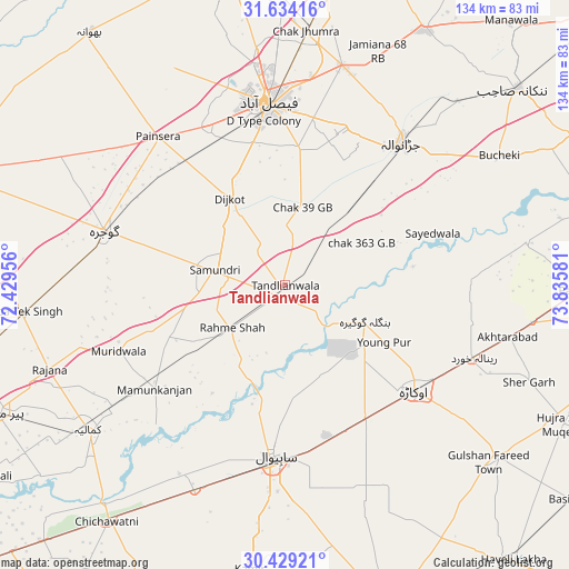
Tandlianwala GPS coordinates[2]
31° 2' 0.924" North, 73° 7' 57.648" East
| Map corner | latitude | longitude |
|---|---|---|
| Upper-left | 31.63416°, | 72.42956° |
| Center: | 31.03359°, | 73.13268° |
| Lower-right: | 30.42921°, | 73.83581° |
| Map W x H: | 134×134 km | = 83.3×83.3mi |
| max Lat: | 36.32162° ⇑45.4% North |
| Tandlianwala: | 31.03359° |
| min Lat: | ⇓54.6% South 24.14422° |
| min Long | Tandlianwala | max Long |
| 61.74573° | 73.13268° | 75.63372° |
| W 75.4%⇐ | ⇒24.6% E |
Elevation
Elevation of Tandlianwala is 184 m = 604 ft, and this is 161 m = 528 ft below average elevation for this country.
| Max E: |
2732 m = 8963 ft | 47.4% |
| Avg. | 345 m = 1132 ft | |
| Tandlianwala | 184 m = 604 ft | |
Min E: |
3 m = 10 ft | 52.6% |
See also: Pakistan elevation on elevation.city.
Geographical zone
Tandlianwala is located in North temperate zone (between Tropic of Cancer and the Arctic Circle). Distance of this Northern Tropic circle is 844.7 km =524.9 mi to South.| Distance of | km | miles | from Tandlianwala |
|---|---|---|---|
| North Pole | 6556.5 | 4074 | to North |
| Arctic Circle | 3950.6 | 2454.8 | to North |
| Tropic Cancer | 844.7 | 524.9 | to South |
| Equator | 3450.6 | 2144.1 | to South |


Nearby cities:
15 places around Tandlianwala: (largest is in red/bold)
• Bahawalnagar
59.1 km =36.7 mi,  155°
155°
• Chak Azam Sahu
32.9 km =20.4 mi,  197°
197°
• Chak Jhumra
59.6 km =37 mi,  4°
4°
• Dijkot
24.2 km =15 mi,  327°
327°
• Faisalabad
42.7 km =26.5 mi,  354°
354°
• Gojra
44.7 km =27.8 mi,  286°
286°
• Jaranwala
43 km =26.7 mi,  39°
39°
• Kamalia
57.6 km =35.8 mi,  233°
233°
• Khurrianwala
53.4 km =33.2 mi,  13°
13°
• Mamu Kanjan
39 km =24.2 mi, 234°
• Mustafābād
38.3 km =23.8 mi,  114°
114°
• Okara
39.3 km =24.4 mi,  129°
129°
• Renala Khurd
47.6 km =29.6 mi, 111°
• Sahiwal
41 km =25.5 mi,  184°
184°
• Toba Tek Singh
62.3 km =38.7 mi,  263°
263°
Sources, notices
• [Note1] Compared only with cities in Pakistan existing in our database
• [Src1] Map data: © OpenStreetMap contributors (CC-BY-SA)
• [Src2] Other city data from geonames.org with taken over terms of usage.
• [Src3] Geographical zone / Annual Mean Temperature by Robert A. Rohde @ Wikipedia
