Kasur geodata
Kasur (Punjab) is a seat of a second-order administrative division; located in Pakistan in Asia/Karachi (GMT+5) time zone. With population of 290,643 people, there are 25 cities with bigger population in this country. Compared to other cities in Pakistan, 54.9% of cities are located further ↓South; 95.9% of cities are located further ←West and 63% of cities have lower elevation than Kasur. Note1


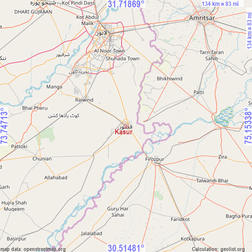
Kasur GPS coordinates[2]
31° 7' 7.176" North, 74° 27' 0.9" East
| Map corner | latitude | longitude |
|---|---|---|
| Upper-left | 31.71869°, | 73.74713° |
| Center: | 31.11866°, | 74.45025° |
| Lower-right: | 30.51481°, | 75.15338° |
| Map W x H: | 133.9×133.9 km | = 83.2×83.2mi |
| max Lat: | 36.32162° ⇑45.1% North |
| Kasur: | 31.11866° |
| min Lat: | ⇓54.9% South 24.14422° |
| min Long | Kasur | max Long |
| 61.74573° | 74.45025° | 75.63372° |
| W 95.9%⇐ | ⇒4.1% E |
Elevation
Elevation of Kasur is 213 m = 699 ft, and this is 132 m = 433 ft below average elevation for this country.
| Max E: |
2732 m = 8963 ft | 37% |
| Avg. | 345 m = 1132 ft | |
| Kasur | 213 m = 699 ft | |
Min E: |
3 m = 10 ft | 63% |
See also: Kasur elevation on elevation.city.
Geographical zone
Kasur is located in North temperate zone (between Tropic of Cancer and the Arctic Circle). Distance of this Northern Tropic circle is 854.2 km =530.8 mi to South.| Distance of | km | miles | from Kasur |
|---|---|---|---|
| North Pole | 6547 | 4068.1 | to North |
| Arctic Circle | 3941.1 | 2448.9 | to North |
| Tropic Cancer | 854.2 | 530.8 | to South |
| Equator | 3460.1 | 2150 | to South |


Nearby cities:
15 places around Kasur: (largest is in red/bold)
• Chak Five Hundred Seventy-five
75.7 km =47 mi,  308°
308°
• Chunian
48 km =29.8 mi,  249°
249°
• Hujra Shah Muqim
73 km =45.4 mi,  234°
234°
• Kahna Nau
28.7 km =17.8 mi,  344°
344°
• Kanganpur
50.2 km =31.2 mi,  218°
218°
• Kot Radha Kishan
33.7 km =20.9 mi,  279°
279°
• Lahore
49.8 km =30.9 mi,  349°
349°
• Mianke Mor
48.6 km =30.2 mi, 281°
• Muridke
78.2 km =48.6 mi, 346°
• Nankana Sahib
79.7 km =49.5 mi,  297°
297°
• Pattoki
57.9 km =36 mi,  259°
259°
• Raiwind
26.6 km =16.5 mi, 302°
• Raja Jang
21.8 km =13.5 mi, 301°
• Sharqpur Sharif
50.5 km =31.4 mi,  318°
318°
• Shekhupura
79.4 km =49.3 mi,  326°
326°
Sources, notices
• [Note1] Compared only with cities in Pakistan existing in our database
• [Src1] Map data: © OpenStreetMap contributors (CC-BY-SA)
• [Src2] Other city data from geonames.org with taken over terms of usage.
• [Src3] Geographical zone / Annual Mean Temperature by Robert A. Rohde @ Wikipedia
