Raiwind geodata
Raiwind (Punjab) is a populated place; located in Pakistan in Asia/Karachi (GMT+5) time zone. With population of 31,592 people, there are 201 cities with bigger population in this country. Compared to other cities in Pakistan, 56.7% of cities are located further ↓South; 93% of cities are located further ←West and 61.2% of cities have lower elevation than Raiwind. Note1


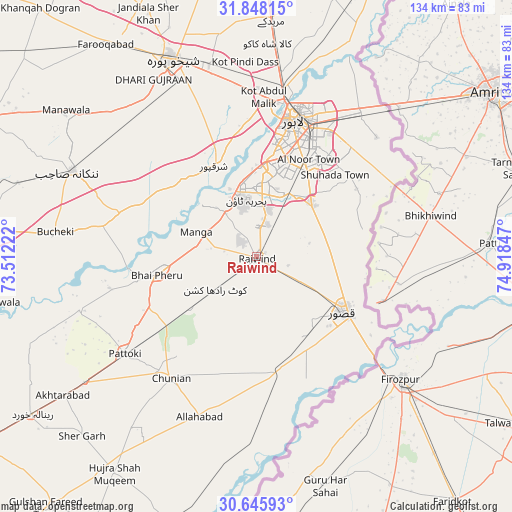
Raiwind GPS coordinates[2]
31° 14' 56.22" North, 74° 12' 55.224" East
| Map corner | latitude | longitude |
|---|---|---|
| Upper-left | 31.84815°, | 73.51222° |
| Center: | 31.24895°, | 74.21534° |
| Lower-right: | 30.64593°, | 74.91847° |
| Map W x H: | 133.7×133.7 km | = 83.1×83.1mi |
| max Lat: | 36.32162° ⇑43.3% North |
| Raiwind: | 31.24895° |
| min Lat: | ⇓56.7% South 24.14422° |
| min Long | Raiwind | max Long |
| 61.74573° | 74.21534° | 75.63372° |
| W 93%⇐ | ⇒7% E |
Elevation
Elevation of Raiwind is 209 m = 686 ft, and this is 136 m = 446 ft below average elevation for this country.
| Max E: |
2732 m = 8963 ft | 38.8% |
| Avg. | 345 m = 1132 ft | |
| Raiwind | 209 m = 686 ft | |
Min E: |
3 m = 10 ft | 61.2% |
See also: Pakistan elevation on elevation.city.
Geographical zone
Raiwind is located in North temperate zone (between Tropic of Cancer and the Arctic Circle). Distance of this Northern Tropic circle is 868.6 km =539.7 mi to South.| Distance of | km | miles | from Raiwind |
|---|---|---|---|
| North Pole | 6532.5 | 4059.1 | to North |
| Arctic Circle | 3926.6 | 2439.9 | to North |
| Tropic Cancer | 868.6 | 539.7 | to South |
| Equator | 3474.6 | 2159 | to South |


Nearby cities:
15 places around Raiwind: (largest is in red/bold)
• Chak Five Hundred Seventy-five
49.3 km =30.6 mi,  311°
311°
• Chunian
38.7 km =24 mi,  215°
215°
• Kahna Nau
19.6 km =12.2 mi,  48°
48°
• Kanganpur
54.6 km =33.9 mi,  189°
189°
• Kasur
26.6 km =16.5 mi,  122°
122°
• Kot Radha Kishan
13.9 km =8.6 mi,  231°
231°
• Lahore
36.7 km =22.8 mi,  20°
20°
• Mananwala
62.6 km =38.9 mi, 307°
• Mianke Mor
25.9 km =16.1 mi,  258°
258°
• Muridke
61.7 km =38.3 mi,  3°
3°
• Nankana Sahib
53.2 km =33.1 mi,  294°
294°
• Pattoki
42.8 km =26.6 mi, 233°
• Raja Jang
4.9 km =3 mi,  129°
129°
• Sharqpur Sharif
26 km =16.2 mi,  335°
335°
• Shekhupura
56 km =34.8 mi, 337°
Sources, notices
• [Note1] Compared only with cities in Pakistan existing in our database
• [Src1] Map data: © OpenStreetMap contributors (CC-BY-SA)
• [Src2] Other city data from geonames.org with taken over terms of usage.
• [Src3] Geographical zone / Annual Mean Temperature by Robert A. Rohde @ Wikipedia
